File:Queen Mary Coast, Antarctica.jpg

Original file (2,800 × 3,600 pixels, file size: 1.74 MB, MIME type: image/jpeg)
Captions
Captions
Summary
[edit]
| Description |
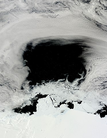
English: As the day of the summer solstice, 2012, dawned on the Queen Mary Coast, Antarctica, the light of the all-day sun reflected a brilliant image of cloud, sea and ice. Although the colors are simple and stark � just black and white � a full palette of texture captures the dynamic motion of the frozen, yet restless region.
In the south, the snow and ice covered land of the Queen Mary Coast appears bright white and nearly smooth in appearance. Just to the north of the coast, melting sea ice drifts in a chaotic mass � a chaos that creates delicate swirls in the blackness of the Davis Sea. An arc of dull white clouds dominates the north section of the image, illustrating the strong and changeable winds that howl in this region. Although spectacular at low resolution, the textures and contrasting colors are even more revealing at high resolution. Viewing the blackness of the Davis Sea at 500 m resolution reveals numerous white dots (icebergs) speckling the black waters, giving the impression of a starry night against a deep velvet sky. In the melting sea ice, individual large chunks of ice can be seen surrounded by a ring of black ocean, and wisps of dull white cloud can be seen blowing over the stark white land below. The Moderate Resolution Imaging Spectroradiometer (MODIS) aboard NASA�s Terra satellite captured this true-color image of the Queen Mary Coast on December 21, 2012 at 2:35 UTC. The summer solstice arrived on the same day at 11:12 UTC. |
| Date | |
| Source |
http://spaceref.com/news/viewsr.html?pid=43022 https://modis.gsfc.nasa.gov/gallery/individual.php?db_date=2013-01-03 |
| Author | Jeff Schmaltz, MODIS Land Rapid Response Team, NASA GSFC |
| Camera location | | View this and other nearby images on: OpenStreetMap |
|---|
Licensing
[edit]
| This file is in the public domain in the United States because it was solely created by NASA. NASA copyright policy states that "NASA material is not protected by copyright unless noted". (See Template:PD-USGov, NASA copyright policy page or JPL Image Use Policy.) | ||
 |
Warnings:
|
File history
Click on a date/time to view the file as it appeared at that time.
| Date/Time | Thumbnail | Dimensions | User | Comment | |
|---|---|---|---|---|---|
| current | 20:42, 27 March 2020 | | 2,800 × 3,600 (1.74 MB) | Qtz arenite (talk | contribs) | Uploaded a work by Jeff Schmaltz, MODIS Land Rapid Response Team, NASA GSFC from http://spaceref.com/news/viewsr.html?pid=43022 https://modis.gsfc.nasa.gov/gallery/individual.php?db_date=2013-01-03 with UploadWizard |
You cannot overwrite this file.
File usage on Commons
The following page uses this file: