File:Queen's Quay - Geograph-3787676-by-The-Carlisle-Kid.jpg
Jump to navigation
Jump to search

Size of this preview: 800 × 593 pixels. Other resolutions: 320 × 237 pixels | 640 × 474 pixels | 1,000 × 741 pixels.
Original file (1,000 × 741 pixels, file size: 496 KB, MIME type: image/jpeg)
Captions
Captions
Add a one-line explanation of what this file represents
Summary
[edit]
| Description |
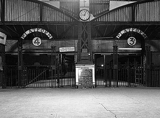
English: Queen's Quay station - interior - 1976 (9) Entrance gates to Platforms 4 & 3, taken on the evening of closure. The chalk-board detailed the revised train service operating that day, the timetable being curtailed due to track work at Ballymacarrett Junction. Location is approximate as the station was demolished following closure, with the site now under the cross-harbour rail and road link. |
| Date | |
| Source | From geograph.org.uk |
| Author | The Carlisle Kid |
| Permission (Reusing this file) |
Creative Commons Attribution Share-alike license 2.0 |
| Attribution (required by the license) | The Carlisle Kid / Queen's Quay station - interior - 1976 (9) / |
| Camera location | | View this and other nearby images on: OpenStreetMap |
|---|
_region:GB-NIR_heading:67.00&language=en)
| Object location | | View this and other nearby images on: OpenStreetMap |
|---|
_region:GB-NIR_heading:67.00&language=en)
Licensing
[edit]

|
This image was taken from the Geograph project collection. See this photograph's page on the Geograph website for the photographer's contact details. The copyright on this image is owned by The Carlisle Kid and is licensed for reuse under the Creative Commons Attribution-ShareAlike 2.0 license.
|
This file is licensed under the Creative Commons Attribution-Share Alike 2.0 Generic license.
Attribution: The Carlisle Kid
- You are free:
- to share – to copy, distribute and transmit the work
- to remix – to adapt the work
- Under the following conditions:
- attribution – You must give appropriate credit, provide a link to the license, and indicate if changes were made. You may do so in any reasonable manner, but not in any way that suggests the licensor endorses you or your use.
- share alike – If you remix, transform, or build upon the material, you must distribute your contributions under the same or compatible license as the original.
File history
Click on a date/time to view the file as it appeared at that time.
| Date/Time | Thumbnail | Dimensions | User | Comment | |
|---|---|---|---|---|---|
| current | 21:38, 27 January 2020 | | 1,000 × 741 (496 KB) | Lamberhurst (talk | contribs) | == {{int:filedesc}} == {{Information |Description={{en|1=<b>Queen's Quay station - interior - 1976 (9)</b><br>Entrance gates to Platforms 4 & 3, taken on the evening of closure. The chalk-board detailed the revised train service operating that day, the timetable being curtailed due to track work at Ballymacarrett Junction. Location is approximate as the station was demolished following closure, with the site now under the cross-harbour rail and road link.}} |Source=From [https://www.geograph.... |
You cannot overwrite this file.
File usage on Commons
The following page uses this file: