File:Quay at Horrid Hill - geograph.org.uk - 371477.jpg
Jump to navigation
Jump to search
No higher resolution available.
Quay_at_Horrid_Hill_-_geograph.org.uk_-_371477.jpg (640 × 478 pixels, file size: 114 KB, MIME type: image/jpeg)
Captions
Captions
Add a one-line explanation of what this file represents
Summary
[edit]
| Description |
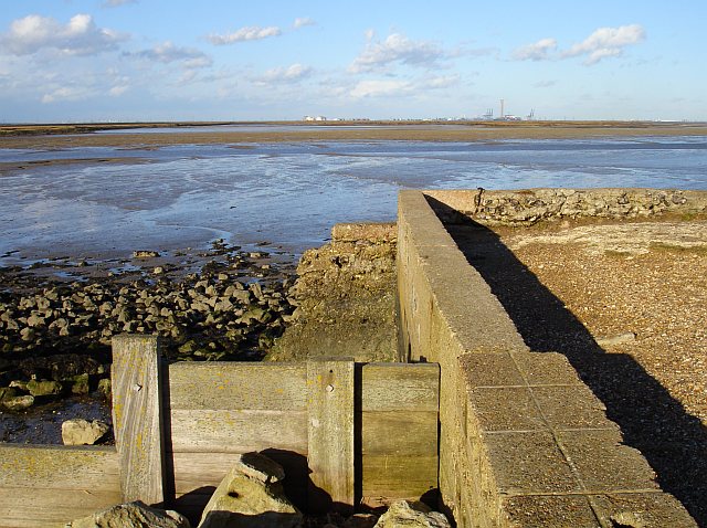
English: Quay at Horrid Hill Horrid Hill was an island until a causeway was built to allow a small horse-drawn railway to carry wagonloads of chalk, quarried from Twydall chalk pit, to the cement works. Warship hulks containing French prisoners of war were moored here during the Napoleonic Wars. It is now part of Riverside Country Park.
On the horizon, beyond Nor Marsh are the storage tanks of the disused oil refinery, cranes at Thamesport and Grain Power Station. |
| Date | |
| Source | From geograph.org.uk |
| Author | Penny Mayes |
| Attribution (required by the license) | Penny Mayes / Quay at Horrid Hill / |
| Camera location | | View this and other nearby images on: OpenStreetMap |
|---|
_heading:45.00&language=en)
| Object location | | View this and other nearby images on: OpenStreetMap |
|---|
_heading:45.00&language=en)
Licensing
[edit]

|
This image was taken from the Geograph project collection. See this photograph's page on the Geograph website for the photographer's contact details. The copyright on this image is owned by Penny Mayes and is licensed for reuse under the Creative Commons Attribution-ShareAlike 2.0 license.
|
This file is licensed under the Creative Commons Attribution-Share Alike 2.0 Generic license.
Attribution: Penny Mayes
- You are free:
- to share – to copy, distribute and transmit the work
- to remix – to adapt the work
- Under the following conditions:
- attribution – You must give appropriate credit, provide a link to the license, and indicate if changes were made. You may do so in any reasonable manner, but not in any way that suggests the licensor endorses you or your use.
- share alike – If you remix, transform, or build upon the material, you must distribute your contributions under the same or compatible license as the original.
File history
Click on a date/time to view the file as it appeared at that time.
| Date/Time | Thumbnail | Dimensions | User | Comment | |
|---|---|---|---|---|---|
| current | 21:16, 4 January 2011 | | 640 × 478 (114 KB) | GeographBot (talk | contribs) | == {{int:filedesc}} == {{Information |description={{en|1=Quay at Horrid Hill Horrid Hill was an island until a causeway was built to allow a small horse-drawn railway to carry wagonloads of chalk, quarried from Twydall chalk pit, to the cement works. Wars |
You cannot overwrite this file.
File usage on Commons
There are no pages that use this file.