File:Qld circle map election results 2017.png
Jump to navigation
Jump to search

Size of this preview: 212 × 600 pixels. Other resolutions: 85 × 240 pixels | 169 × 480 pixels | 271 × 768 pixels | 1,059 × 2,996 pixels.
Original file (1,059 × 2,996 pixels, file size: 129 KB, MIME type: image/png)
Captions
Captions
Add a one-line explanation of what this file represents
Summary
[edit]| Description |
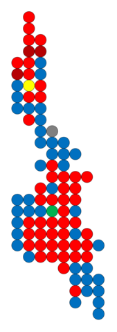
English: A map depicting each of the electoral districts of the Queensland Legislative Assembly as equally sized circles, with colours representing the winning party at the 2017 election based on provisional results as at 1 December 2017. |
||
| Date | |||
| Source |
This file was derived from: Qld Legislative Assembly circle map.png |
||
| Author | Neegzistuoja | ||
| Other versions |
|

Licensing
[edit]
| This image of simple geometry is ineligible for copyright and therefore in the public domain, because it consists entirely of information that is common property and contains no original authorship. |  |
File history
Click on a date/time to view the file as it appeared at that time.
| Date/Time | Thumbnail | Dimensions | User | Comment | |
|---|---|---|---|---|---|
| current | 04:09, 1 December 2017 | 1,059 × 2,996 (129 KB) | Neegzistuoja (talk | contribs) | User created page with UploadWizard |
You cannot overwrite this file.
File usage on Commons
The following page uses this file: