File:Qingzangrailwaymap.gif
Jump to navigation
Jump to search

Size of this preview: 800 × 526 pixels. Other resolutions: 320 × 210 pixels | 640 × 421 pixels.
Original file (913 × 600 pixels, file size: 271 KB, MIME type: image/gif)
Captions
Captions
Add a one-line explanation of what this file represents
Summary
[edit]
| Description |
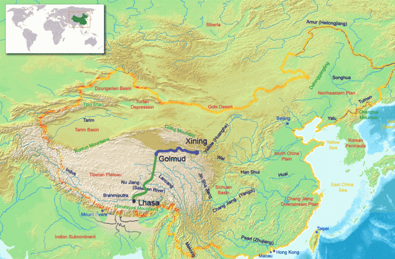
Nederlands: Kaart van de Qingzang spoorweg (Peking-Lhasa). Inspired by a graphic at https://www.wired.com/wired/archive/14.07/chinarail.html Partly based on Image:ChinaGeography.png |
| Date |
7 July 2006 (original upload date) |
| Source | Engelstalige wikipedia |
| Author | (Original text: Guinnog) |
Licensing
[edit]
Guinnog at the English-language Wikipedia, the copyright holder of this work, hereby publishes it under the following license:

|
Permission is granted to copy, distribute and/or modify this document under the terms of the GNU Free Documentation License, Version 1.2 or any later version published by the Free Software Foundation; with no Invariant Sections, no Front-Cover Texts, and no Back-Cover Texts. A copy of the license is included in the section entitled GNU Free Documentation License. |
| This file is licensed under the Creative Commons Attribution-Share Alike 3.0 Unported license. | ||
| Attribution: Guinnog | ||
| ||
| This licensing tag was added to this file as part of the GFDL licensing update. |
Original upload log
[edit]
The original description page was here. All following user names refer to nl.wikipedia.
- 2006-07-07 10:28 Erik Baas 913×600×8 (277682 bytes) Kaart van de Qingzang spoorweg (Peking-Lhasa). Bewerkte kopie van http://en.wikipedia.org/wiki/Image:Qingzangrailwaymap.png. "GNU Free Documentation License"
File history
Click on a date/time to view the file as it appeared at that time.
| Date/Time | Thumbnail | Dimensions | User | Comment | |
|---|---|---|---|---|---|
| current | 01:00, 11 May 2008 | | 913 × 600 (271 KB) | File Upload Bot (Magnus Manske) (talk | contribs) | {{BotMoveToCommons|nl.wikipedia}} {{Information |Description={{nl|Kaart van de Qingzang spoorweg (Peking-Lhasa).<br/><small>''Inspired by a graphic at http://www.wired.com/wired/archive/14.07/chinarail.html Partly based on Image:ChinaGeography.png''</sma |
You cannot overwrite this file.
File usage on Commons
There are no pages that use this file.
File usage on other wikis
The following other wikis use this file:
- Usage on eo.wikipedia.org