File:Qing 1820 CHGIS.png
Jump to navigation
Jump to search

Size of this preview: 800 × 565 pixels. Other resolutions: 320 × 226 pixels | 640 × 452 pixels | 1,024 × 724 pixels | 1,280 × 905 pixels | 2,560 × 1,809 pixels | 7,018 × 4,960 pixels.
Original file (7,018 × 4,960 pixels, file size: 685 KB, MIME type: image/png)
Captions
Captions
Add a one-line explanation of what this file represents
Summary
[edit]
| Description |
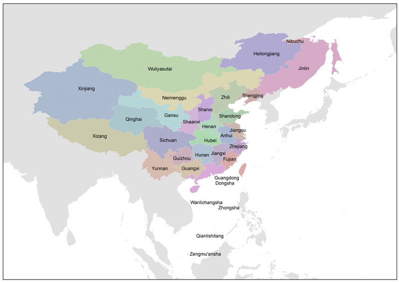
English: A reprojected map on China's Qing Dynasty 1820, based on the "CHGIS, Version 5" Cambridge: Fairbank Center for Chinese Studies, Sep 2011."
|
| Date | |
| Source | Own work |
| Author | Hanteng |
Licensing
[edit]
I, the copyright holder of this work, hereby publish it under the following license:
This file is licensed under the Creative Commons Attribution-Share Alike 3.0 Unported license.
- You are free:
- to share – to copy, distribute and transmit the work
- to remix – to adapt the work
- Under the following conditions:
- attribution – You must give appropriate credit, provide a link to the license, and indicate if changes were made. You may do so in any reasonable manner, but not in any way that suggests the licensor endorses you or your use.
- share alike – If you remix, transform, or build upon the material, you must distribute your contributions under the same or compatible license as the original.
File history
Click on a date/time to view the file as it appeared at that time.
| Date/Time | Thumbnail | Dimensions | User | Comment | |
|---|---|---|---|---|---|
| current | 04:43, 2 April 2014 | | 7,018 × 4,960 (685 KB) | Hanteng (talk | contribs) | User created page with UploadWizard |
You cannot overwrite this file.
File usage on Commons
There are no pages that use this file.
File usage on other wikis
The following other wikis use this file:
- Usage on bn.wikipedia.org
- Usage on es.wikipedia.org
- Usage on fr.wikipedia.org
- Usage on zh.wikipedia.org