File:Q site night bombing decoy - geograph.org.uk - 91160.jpg
Jump to navigation
Jump to search
No higher resolution available.
Q_site_night_bombing_decoy_-_geograph.org.uk_-_91160.jpg (640 × 429 pixels, file size: 78 KB, MIME type: image/jpeg)
Captions
Captions
Add a one-line explanation of what this file represents
Summary
[edit]
| Description |
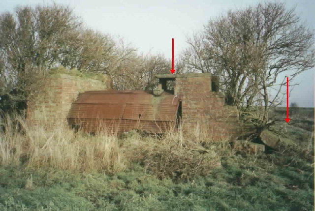
English: Q site night bombing decoy. Near Formby at Downholland Moss the remains of control shelter for a Q site still stand. Q sites were night bombing decoys. This one was built to decoy RAF Woodvale further up the coast. The Q site itself was almost one and a half miles long and was intended to represent an airfield at night and consisted of a dummy flarepath for landing aircraft and a v-shaped approach funnel. The centre arrow shows where a car headlight was located that was rotated to simulate a taxiing aircraft. The arrow on the right shows the remains of a blast wall, now collapsed.
For more info visit http://www.pillboxesuk.co.uk |
| Date | |
| Source | From geograph.org.uk |
| Author | Ian Sanders |
| Attribution (required by the license) | Ian Sanders / Q site night bombing decoy / |
| Object location | | View this and other nearby images on: OpenStreetMap |
|---|
_&language=en)
Licensing
[edit]

|
This image was taken from the Geograph project collection. See this photograph's page on the Geograph website for the photographer's contact details. The copyright on this image is owned by Ian Sanders and is licensed for reuse under the Creative Commons Attribution-ShareAlike 2.0 license.
|
This file is licensed under the Creative Commons Attribution-Share Alike 2.0 Generic license.
Attribution: Ian Sanders
- You are free:
- to share – to copy, distribute and transmit the work
- to remix – to adapt the work
- Under the following conditions:
- attribution – You must give appropriate credit, provide a link to the license, and indicate if changes were made. You may do so in any reasonable manner, but not in any way that suggests the licensor endorses you or your use.
- share alike – If you remix, transform, or build upon the material, you must distribute your contributions under the same or compatible license as the original.
- Remove redundant categories and try to put this image in the most specific category/categories
- Remove this template
- The location categories are based on information from this geonames tool and this OpenStreetMap tool combined with a database. You can also have a look at this tool from mysociety.
- The topic category from Geograph was Pillbox (find similar images at Geograph)
File history
Click on a date/time to view the file as it appeared at that time.
| Date/Time | Thumbnail | Dimensions | User | Comment | |
|---|---|---|---|---|---|
| current | 00:16, 31 January 2010 | | 640 × 429 (78 KB) | GeographBot (talk | contribs) | == {{int:filedesc}} == {{Information |description={{en|1=Q site night bombing decoy. Near Formby at Downholland Moss the remains of control shelter for a Q site still stand. Q sites were night bombing decoys. This one was built to decoy RAF Woodvale furth |
You cannot overwrite this file.
File usage on Commons
There are no pages that use this file.