File:Pulau Padar Kawasan Taman Nasional Komodo.jpg
![File:Pulau Padar Kawasan Taman Nasional Komodo.jpg](https://upload.wikimedia.org/wikipedia/commons/thumb/a/ac/Pulau_Padar_Kawasan_Taman_Nasional_Komodo.jpg/800px-Pulau_Padar_Kawasan_Taman_Nasional_Komodo.jpg?20220501033129)
Original file (9,122 × 3,704 pixels, file size: 6.22 MB, MIME type: image/jpeg)
Captions
Captions
Summary
[edit]DescriptionPulau Padar Kawasan Taman Nasional Komodo.jpg |
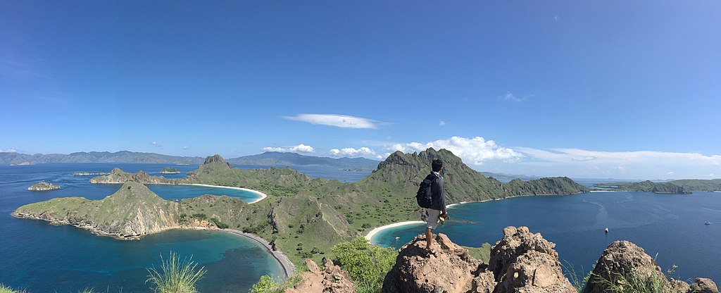
Bahasa Indonesia: Pulau Padar adalah salah satu pulau yang termasuk wilayah konservasi Taman Nasional Komodo. Pulau Padar dapat dijangkau melalui jalur transportasi laut. Waktu tempuhnya sekitar 3-4 jam dari Pelabuhan Labuan Bajo. Pulau Padar adalah salah satu pulau yang wajib dikunjungi ketika berwisata ke Taman Nasional Komodo. Untuk menikmati panorama Pulau Padar, pengunjung harus melewati jalur pendakian yang cukup menguras tenaga. Jadi, persiapan fisik dan kebutuhan penunjang lainnya sangat diperlukan. Waktu paling baik mengunjungi Pulau Padar adalah pagi dan sore hari. Jika ingin melihat bentang alam Pulau Padar yang menghijau, datanglah sekitar Bulan Desember hingga Bulan Maret. Sebaliknya, jika ingin melihan bentang alam Pulau Padar yang keoklatan khas padang rumput sabana, datanglah pada Bulan Juli hingga Bulan Agustus. |
Date | |
Source | Own work |
Author | Wigena |
Camera location | 8° 40′ 50.62″ S, 119° 33′ 24.7″ E ![]() ![]() | View this and other nearby images on: OpenStreetMap | ![]() |
---|
Foto ini diambil oleh bukan profesional.
Licensing
[edit]![w:en:Creative Commons](https://upload.wikimedia.org/wikipedia/commons/thumb/7/79/CC_some_rights_reserved.svg/90px-CC_some_rights_reserved.svg.png)
![attribution](https://upload.wikimedia.org/wikipedia/commons/thumb/1/11/Cc-by_new_white.svg/24px-Cc-by_new_white.svg.png)
![share alike](https://upload.wikimedia.org/wikipedia/commons/thumb/d/df/Cc-sa_white.svg/24px-Cc-sa_white.svg.png)
- You are free:
- to share – to copy, distribute and transmit the work
- to remix – to adapt the work
- Under the following conditions:
- attribution – You must give appropriate credit, provide a link to the license, and indicate if changes were made. You may do so in any reasonable manner, but not in any way that suggests the licensor endorses you or your use.
- share alike – If you remix, transform, or build upon the material, you must distribute your contributions under the same or compatible license as the original.
![]() |
This image was uploaded as part of Wiki Loves Earth 2022.
aragonés ∙ asturianu ∙ azərbaycanca ∙ Bahasa Indonesia ∙ Bahasa Melayu ∙ brezhoneg ∙ català ∙ čeština ∙ Cymraeg ∙ dagbanli ∙ Deutsch ∙ eesti ∙ English ∙ español ∙ euskara ∙ français ∙ galego ∙ hrvatski ∙ italiano ∙ latviešu ∙ Nederlands ∙ norsk ∙ norsk bokmål ∙ português ∙ polski ∙ português do Brasil ∙ română ∙ shqip ∙ sicilianu ∙ slovenščina ∙ svenska ∙ Tagalog ∙ Türkçe ∙ Ελληνικά ∙ беларуская (тарашкевіца) ∙ български ∙ македонски ∙ русский ∙ српски / srpski ∙ українська ∙ ქართული ∙ հայերեն ∙ नेपाली ∙ मराठी ∙ বাংলা ∙ മലയാളം ∙ ไทย ∙ 한국어 ∙ 日本語 ∙ 中文 ∙ 中文(台灣) ∙ 中文(简体) ∙ 中文(繁體) ∙ עברית ∙ اردو ∙ العربية ∙ فارسی ∙ +/− |
![]() |
File history
Click on a date/time to view the file as it appeared at that time.
Date/Time | Thumbnail | Dimensions | User | Comment | |
---|---|---|---|---|---|
current | 03:31, 1 May 2022 | ![]() | 9,122 × 3,704 (6.22 MB) | Wigena (talk | contribs) | Uploaded own work with UploadWizard |
You cannot overwrite this file.
File usage on Commons
There are no pages that use this file.
Metadata
This file contains additional information such as Exif metadata which may have been added by the digital camera, scanner, or software program used to create or digitize it. If the file has been modified from its original state, some details such as the timestamp may not fully reflect those of the original file. The timestamp is only as accurate as the clock in the camera, and it may be completely wrong.
Camera manufacturer | Apple |
---|---|
Camera model | iPhone 6s |
Exposure time | 1/2,024 sec (0.00049407114624506) |
F-number | f/2.2 |
ISO speed rating | 25 |
Date and time of data generation | 09:54, 25 February 2020 |
Lens focal length | 4.15 mm |
Latitude | 8° 40′ 50.62″ S |
Longitude | 119° 33′ 24.7″ E |
Altitude | 120.8 meters above sea level |
Orientation | Normal |
Horizontal resolution | 72 dpi |
Vertical resolution | 72 dpi |
Software used | 13.1.1 |
File change date and time | 09:54, 25 February 2020 |
Exif version | 2.31 |
Date and time of digitizing | 09:54, 25 February 2020 |
Meaning of each component |
|
APEX shutter speed | 10.983201343892 |
APEX aperture | 2.2750070478485 |
APEX brightness | 10.918943672722 |
APEX exposure bias | 0 |
Metering mode | Pattern |
Flash | Flash did not fire |
DateTimeOriginal subseconds | 978 |
DateTimeDigitized subseconds | 978 |
Supported Flashpix version | 1 |
Color space | sRGB |
Sensing method | One-chip color area sensor |
Scene type | A directly photographed image |
Custom image processing | Panorama |
White balance | Auto white balance |
Focal length in 35 mm film | 29 mm |
Scene capture type | Standard |
Speed unit | Kilometers per hour |
Speed of GPS receiver | 0 |
Reference for direction of image | True direction |
Direction of image | 17.35693359375 |
Reference for bearing of destination | True direction |
Bearing of destination | 17.35693359375 |
IIM version | 2 |
Structured data
Items portrayed in this file
depicts
8°40'50.621"S, 119°33'24.700"E
25 February 2020
0.00049407114624505928 second
2.2
4.15 millimetre
image/jpeg
- Images from Wiki Loves Earth 2022 in Indonesia - landscape
- Files with coordinates missing SDC location of creation
- CC-BY-SA-4.0
- Self-published work
- Images from Wiki Loves Earth 2022
- Images from Wiki Loves Earth 2022 in Indonesia
- Images from Wiki Loves Earth missing SDC location of creation
- Uploaded via Campaign:wle-id
- Indonesia photographs taken on 2020-02-25
- Pages with maps