File:Public footpath at Albert Dock, Hull - geograph.org.uk - 233006.jpg
Jump to navigation
Jump to search
Size of this preview: 448 × 600 pixels. Other resolutions: 179 × 240 pixels | 478 × 640 pixels.
Original file (478 × 640 pixels, file size: 66 KB, MIME type: image/jpeg)
Captions
Captions
Add a one-line explanation of what this file represents
Summary
[edit]
| Description |
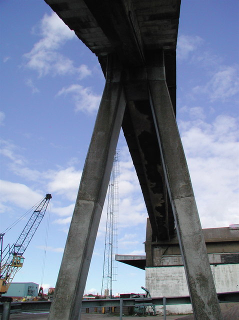
English: Public footpath at Albert Dock, Hull, East Riding of Yorkshire, England. A public right of way has been maintained right through the docks area of Hull almost as far as the chemical works at Salt End to the east of the city, although it appears this right of way might now be cut short there with the building of a new incinerator. Here at Albert Dock some of the storage sheds are against the river wall leaving little room for safe public access, so this raised walkway allows people to pass up and over the shed roofs and down the other side. |
| Date | |
| Source | From geograph.org.uk |
| Author | Paul Glazzard |
| Permission (Reusing this file) |
Creative Commons Attribution Share-alike license 2.0 |
| Attribution (required by the license) | Paul Glazzard / Public footpath at Albert Dock, Hull / |
| Camera location | | View this and other nearby images on: OpenStreetMap |
|---|
| Object location | | View this and other nearby images on: OpenStreetMap |
|---|
_heading:45.00&language=en)
Licensing
[edit]

|
This image was taken from the Geograph project collection. See this photograph's page on the Geograph website for the photographer's contact details. The copyright on this image is owned by Paul Glazzard and is licensed for reuse under the Creative Commons Attribution-ShareAlike 2.0 license.
|
This file is licensed under the Creative Commons Attribution-Share Alike 2.0 Generic license.
Attribution: Paul Glazzard
- You are free:
- to share – to copy, distribute and transmit the work
- to remix – to adapt the work
- Under the following conditions:
- attribution – You must give appropriate credit, provide a link to the license, and indicate if changes were made. You may do so in any reasonable manner, but not in any way that suggests the licensor endorses you or your use.
- share alike – If you remix, transform, or build upon the material, you must distribute your contributions under the same or compatible license as the original.
File history
Click on a date/time to view the file as it appeared at that time.
| Date/Time | Thumbnail | Dimensions | User | Comment | |
|---|---|---|---|---|---|
| current | 01:58, 1 February 2010 | | 478 × 640 (66 KB) | GeographBot (talk | contribs) | == {{int:filedesc}} == {{Information |description={{en|1=Public footpath at Albert Dock, Hull. A public right of way has been maintained right through the docks area of Hull almost as far as the chemical works at Salt End to the east of the city, although |
You cannot overwrite this file.
File usage on Commons
There are no pages that use this file.