File:Ptolemy, Soria e Terra Sancta nova tabula (FL6882088 2368940).jpg
Jump to navigation
Jump to search

Size of this preview: 800 × 580 pixels. Other resolutions: 320 × 232 pixels | 640 × 464 pixels | 1,024 × 743 pixels | 1,280 × 929 pixels | 2,560 × 1,857 pixels | 2,900 × 2,104 pixels.
Original file (2,900 × 2,104 pixels, file size: 2.52 MB, MIME type: image/jpeg)
Captions
Captions
Add a one-line explanation of what this file represents
Summary
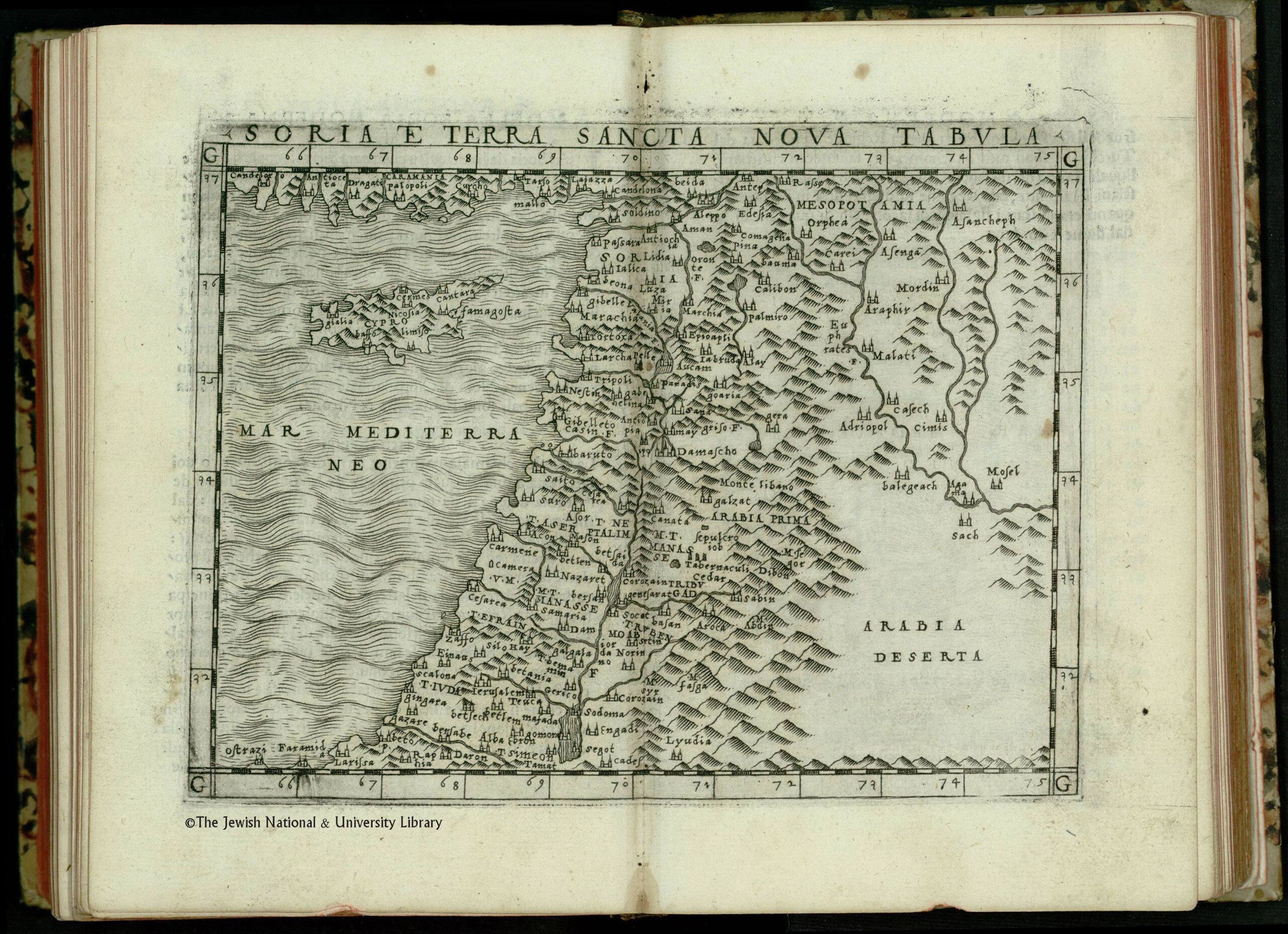
[edit]| Ptolemy: Soria e Terra Sancta nova tabula
( |
||||||||||||||||||||||||
|---|---|---|---|---|---|---|---|---|---|---|---|---|---|---|---|---|---|---|---|---|---|---|---|---|
| Artist |
| |||||||||||||||||||||||
| Contributors | Bascarini, Nicolo Gastaldi, Giacomo, approximately 1500-approximately 1565 | |||||||||||||||||||||||
| Title |
Soria e Terra Sancta nova tabula |
|||||||||||||||||||||||
| Publisher |
Nicolo Bascarini |
|||||||||||||||||||||||
| Description |
Soria e Terra Sancta nova tabula. |
|||||||||||||||||||||||
| Language | Latin | |||||||||||||||||||||||
| Publication date | 1548 | |||||||||||||||||||||||
| Dimensions | height: 130 mm (5.11 in); width: 170 mm (6.69 in) | |||||||||||||||||||||||
| Collection |
|
|||||||||||||||||||||||
| Current location |
|
|||||||||||||||||||||||
| Place of publication | Venice | |||||||||||||||||||||||
| search Merhav catalog | Venice | |||||||||||||||||||||||
| Notes | Copperplate; From: Ptolemaeus, Claudius, Geographia, Venezia, Nicolo Bascari, 1548. Map no. 41. One of the series of Italian maps of Syria and Palestine published in the 16th century. | |||||||||||||||||||||||
| IE PID | IE6882086 | |||||||||||||||||||||||
| Rosetta filename | FL6882088 | |||||||||||||||||||||||
| NNL item ID (P3959) | 990023689400205171 | |||||||||||||||||||||||
| search Merhav catalog | Latin, Ptolemy | |||||||||||||||||||||||
| search Merhav catalog | Twelve tribes of IsraelMapsNicolo Bascarini | |||||||||||||||||||||||
| Source/Photographer |
|
|||||||||||||||||||||||
| Other versions | ||||||||||||||||||||||||
| Jpg / Tif version |
|
|||||||||||||||||||||||


.jpg)

.jpg&action=edit§ion=1)
Licensing
[edit].jpg&action=edit§ion=2)
The copyright situation of this work is theoretically uncertain, because in the country of origin copyright lasts 70 years after the death of the author, and the date of the author's death is unknown. However, the date of creation of the work was over 120 years ago, and it is thus a reasonable assumption that the copyright has expired (see here for the community discussion). Do not use this template if the date of death of the author is known.
| |
| This file has been identified as being free of known restrictions under copyright law, including all related and neighboring rights. | |
File history
Click on a date/time to view the file as it appeared at that time.
| Date/Time | Thumbnail | Dimensions | User | Comment | |
|---|---|---|---|---|---|
| current | 21:59, 28 July 2023 | | 2,900 × 2,104 (2.52 MB) | Geagea (talk | contribs) | pattypan 22.03 |
You cannot overwrite this file.
File usage on Commons
The following page uses this file:
.jpg&oldid=850868769)