File:Przywidz (gmina) location map.png
Jump to navigation
Jump to search

Size of this preview: 590 × 600 pixels. Other resolutions: 236 × 240 pixels | 472 × 480 pixels | 723 × 735 pixels.
Original file (723 × 735 pixels, file size: 128 KB, MIME type: image/png)
Captions
Captions
Add a one-line explanation of what this file represents
| Description |
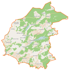
Polski: Mapa gminy Przywidz, Polska
English: Map of Gmina Przywidz, Poland |
|||||||||
| Date | ||||||||||
| Source | You may find a page on the OpenStreetMap wiki page for Przywidz (gmina) | |||||||||
| Creator |
OpenStreetMap contributors OpenStreetMap contributors |
|||||||||
| Permission (Reusing this file) |
OpenStreetMap data is available under the Open Database License (details). Map tiles are licensed under the Creative Commons Attribution-ShareAlike 2.0 license (CC-BY-SA 2.0).
This file is licensed under the Creative Commons Attribution-Share Alike 2.0 Generic license.
|
|||||||||
| Geotemporal data | ||||||||||
| Bounding box |
|
|||||||||
| Georeferencing | If inappropriate please set warp_status = skip to hide. | |||||||||
File history
Click on a date/time to view the file as it appeared at that time.
| Date/Time | Thumbnail | Dimensions | User | Comment | |
|---|---|---|---|---|---|
| current | 17:32, 18 January 2015 | | 723 × 735 (128 KB) | VanWiel (talk | contribs) | {{OpenStreetMap | name = Przywidz (gmina) | location = Przywidz (gmina) | description = {{pl|Mapa gminy Przywidz, Polska}} {{en|Map of Gmina Przywidz, Poland}} | top = 54.2809 | bottom = 54.1333 | l... |
You cannot overwrite this file.
File usage on Commons
There are no pages that use this file.
File usage on other wikis
The following other wikis use this file:
- Usage on pl.wikipedia.org
- Przywidz (gmina)
- Huta Dolna (województwo pomorskie)
- Jodłowno
- Marszewska Góra
- Nowa Wieś Przywidzka
- Piekło Górne
- Pomlewo
- Sucha Huta
- Borowina (województwo pomorskie)
- Kozia Góra (województwo pomorskie)
- Michalin (województwo pomorskie)
- Miłowo (województwo pomorskie)
- Olszanka (województwo pomorskie)
- Przywidz (województwo pomorskie)
- Trzepowo (województwo pomorskie)
- Kierzkowo (powiat gdański)
- Stara Huta (powiat gdański)
- Piekło Dolne
- Jezioro Przywidzkie Wielkie
- Huta Górna
- Czarna Huta (powiat gdański)
- Majdany (Nowa Wieś Przywidzka)
- Roztoka (województwo pomorskie)
- Jezioro Przywidzkie Małe
- Gromadzin (województwo pomorskie)
- Częstocin
- Bliziny
- Katarynki
- Klonowo Górne
- Klonowo Dolne
- Marszewo (województwo pomorskie)
- Ząbrsko Górne
- Ząbrsko Dolne
- Marszewska Kolonia
- Jezioro Połęczyńskie
- Rezerwat przyrody Wyspa na Jeziorze Przywidz
- Jezioro Klonowskie
- Ząbrsko
- Jezioro Głębokie (powiat gdański)
- Jezioro Łąkie (powiat gdański)
- Łąki (Trzepowo)
- Szklana Góra (Kozia Góra)
- Parafia św. Franciszka Ksawerego w Przywidzu
- Rudzina
- Stoszewo
- Zalesie Przywidzkie
- Borzyszewo (województwo pomorskie)
- Pustkowo (województwo pomorskie)
- Parafia Matki Bożej Fatimskiej w Nowej Wsi Przywidzkiej
- Parafia Macierzyństwa Najświętszej Maryi Panny w Jodłownie
View more global usage of this file.
_location_map.png)
_location_map.png&oldid=519993164)