File:Prozessionskreuz aus Limoges.JPG
Jump to navigation
Jump to search

Size of this preview: 439 × 599 pixels. Other resolutions: 176 × 240 pixels | 351 × 480 pixels | 562 × 768 pixels | 750 × 1,024 pixels | 1,500 × 2,048 pixels | 3,313 × 4,524 pixels.
Original file (3,313 × 4,524 pixels, file size: 7.9 MB, MIME type: image/jpeg)
Captions
Captions
Add a one-line explanation of what this file represents
Summary
[edit]| Description |
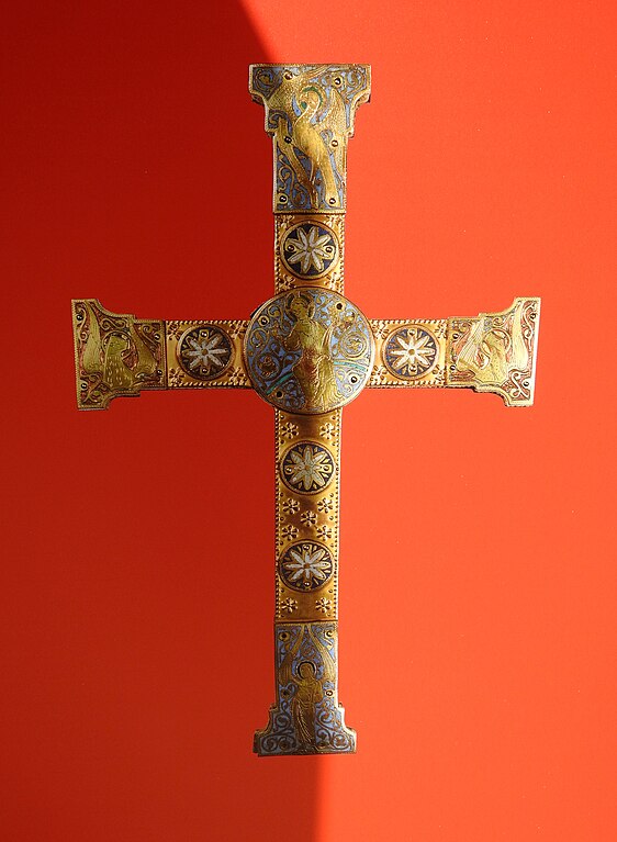
English: Cross made in Limoges, France, around 1300, stolen in Warsaw, Poland, by the Nazis in 1941, brought to Schloss Fischhorn in Bruck an der Großglocknerstraße, Austria, in 1944 by the SS, stolen again in 1945 by an unknown local person, found in 2004 in a bulky waste container in Zell am See, finally given back to the original owners in 2008; this image is a photograph of a photograph shown in "Polnische Kulturschätze im Schloss Fischhorn - eine nicht abgeschlossene Historie", an exhibition taken place in Zell am See in 2015.
Deutsch: Prozessionskreuz, hergestellt Ende des 12. Jahrhunderts in Limoges, Frankreich; 1941 von den Nationalsozialisten aus polnischem Adelsbesitz geraubt, 1944 von SS-Führer Fegelein zusammen mit zahlreichen anderen polnischen Kulturschätzen nach Österreich in das Schloss Fischhorn, Bruck an der Großglocknerstraße, verbracht, 1945 von unbekannter Zivilperson aus der Region erneut gestohlen, 2004 von einer Frau aus Zell am See in einem Sperrmüllcontainer aufgefunden, 2008 an die ursprünglichen Besitzer zurückgegeben; diese Abbildung zeigt ein Foto des Kreuzes, das in der Ausstellung "Polnische Kulturschätze im Schloss Fischhorn - eine nicht abgeschlossene Historie" in Zell am See im Oktober 2015 gezeigt wurde. |
||
| Date | |||
| Source | Own work | ||
| Author | Wald1siedel | ||
| Permission (Reusing this file) |
|

| Camera location | | View this and other nearby images on: OpenStreetMap |
|---|
Licensing
[edit]
I, the copyright holder of this work, hereby publish it under the following license:
This file is licensed under the Creative Commons Attribution-Share Alike 4.0 International license.
- You are free:
- to share – to copy, distribute and transmit the work
- to remix – to adapt the work
- Under the following conditions:
- attribution – You must give appropriate credit, provide a link to the license, and indicate if changes were made. You may do so in any reasonable manner, but not in any way that suggests the licensor endorses you or your use.
- share alike – If you remix, transform, or build upon the material, you must distribute your contributions under the same or compatible license as the original.
File history
Click on a date/time to view the file as it appeared at that time.
| Date/Time | Thumbnail | Dimensions | User | Comment | |
|---|---|---|---|---|---|
| current | 08:31, 6 October 2015 | | 3,313 × 4,524 (7.9 MB) | Wald1siedel (talk | contribs) | {{Information |Description ={{en|1=Cross made in Limoges, France, around 1200 b.C., stolen in Warshava by the Nazis in 1941, transfered to Schloss Fischhorn in Bruck an der Großglocknerstraße in 1944 by the SS, a second time stolen in 1945 by peop... |
You cannot overwrite this file.
File usage on Commons
The following page uses this file:
File usage on other wikis
The following other wikis use this file:
- Usage on it.wikipedia.org
- Usage on ru.wikipedia.org