File:Provisional Government of Western Thrace.png
Jump to navigation
Jump to search
No higher resolution available.
Provisional_Government_of_Western_Thrace.png (712 × 539 pixels, file size: 107 KB, MIME type: image/png)
Captions
Captions
Add a one-line explanation of what this file represents
Summary
[edit]
| Description |
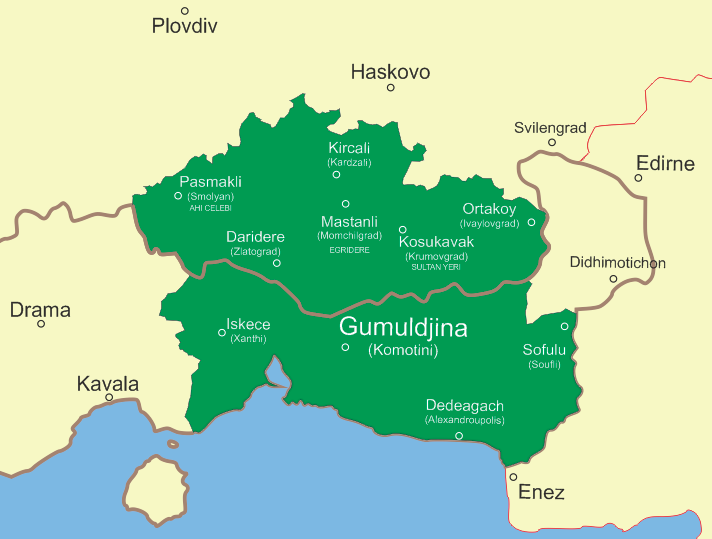
English: Map of the Provisional Government of Western Thrace (1913)
Shown on the map are the capitals of the ten kazas (prefectures) that formed the state. The contemporary names are shown in parentheses. In three cases, Egri Dere, Ahi Celebi and Sultan Yeri, the names of the kazas were different from these of their capitals |
| Date | |
| Source | Own work |
| Author | Japetus |
Licensing
[edit]
I, the copyright holder of this work, hereby publish it under the following license:
This file is licensed under the Creative Commons Attribution-Share Alike 3.0 Unported license.
- You are free:
- to share – to copy, distribute and transmit the work
- to remix – to adapt the work
- Under the following conditions:
- attribution – You must give appropriate credit, provide a link to the license, and indicate if changes were made. You may do so in any reasonable manner, but not in any way that suggests the licensor endorses you or your use.
- share alike – If you remix, transform, or build upon the material, you must distribute your contributions under the same or compatible license as the original.
File history
Click on a date/time to view the file as it appeared at that time.
| Date/Time | Thumbnail | Dimensions | User | Comment | |
|---|---|---|---|---|---|
| current | 07:53, 23 February 2012 | | 712 × 539 (107 KB) | Japetus (talk | contribs) | Better placement of cities on map, changed names to the original ones of the time~~~~ |
| 09:58, 17 February 2012 |  | 713 × 540 (102 KB) | Japetus (talk | contribs) |
You cannot overwrite this file.
File usage on Commons
There are no pages that use this file.
File usage on other wikis
The following other wikis use this file:
- Usage on az.wikipedia.org
- Usage on bg.wikipedia.org
- Usage on cs.wikipedia.org
- Usage on el.wikipedia.org
- Usage on hu.wikipedia.org
- Usage on pl.wikipedia.org
- Usage on pt.wikipedia.org
- Usage on ru.wikipedia.org
- Usage on tr.wikipedia.org
- Usage on uk.wikipedia.org
- Usage on zh.wikipedia.org