File:Provincia de San Salvador (poblaciónes Pipiles y Chontales) 1529 - 1530.svg
Jump to navigation
Jump to search

Size of this PNG preview of this SVG file: 670 × 599 pixels. Other resolutions: 268 × 240 pixels | 537 × 480 pixels | 858 × 768 pixels | 1,145 × 1,024 pixels | 2,289 × 2,048 pixels | 1,263 × 1,130 pixels.
Original file (SVG file, nominally 1,263 × 1,130 pixels, file size: 17 KB)
Captions
Captions
Add a one-line explanation of what this file represents
Summary
[edit]_1529_-_1530.svg&action=edit§ion=1)
| Description |
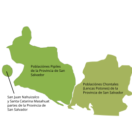
Español: Mapa de la provincia de San Salvador desde 1529, año siguiente a la fundación de la villa y provincia de San Salvador en el territorio del Señorío pipil de Cuzcatlán y a la vez año en que por orden del teniente de gobernador Jorge de Alvarado se les quitaron a los vecinos de San Salvador las poblaciones ubicadas en los actuales departamentos salvadoreños de Ahuachapán y Sonsonante que fueron dados a los vecinos de Santiago de Guatemala, debido a lo cual los habitantes de San Salvador conquistaron las poblaciones Lencas (llamados por los pipiles como Chontales) ubicadas en la actual zona oriental salvadoreña, sin embargo la conquista y pacificación no fue del todo completa. |
| Date | |
| Source | Own work, basado en texto e imagen de Amaroli, Paul (1986) «En la búsqueda de Cuscatlán» y Amaroli, Paul (1991) «Linderos y Geografía Económica de Cuscatlán, Provincia Pipil del Territorio de El Salvador»; y texto de Escalante Arce, Pedro Antonio (1992) «Códice de Sonsonate» y Larde y Larín, Jorge (1983) «El Salvador: descubrimiento, conquista y colonización» |
| Author | Juan Miguel |
Licensing
[edit]_1529_-_1530.svg&action=edit§ion=2)
I, the copyright holder of this work, hereby publish it under the following license:
This file is licensed under the Creative Commons Attribution 3.0 Unported license.
- You are free:
- to share – to copy, distribute and transmit the work
- to remix – to adapt the work
- Under the following conditions:
- attribution – You must give appropriate credit, provide a link to the license, and indicate if changes were made. You may do so in any reasonable manner, but not in any way that suggests the licensor endorses you or your use.
File history
Click on a date/time to view the file as it appeared at that time.
| Date/Time | Thumbnail | Dimensions | User | Comment | |
|---|---|---|---|---|---|
| current | 20:58, 3 February 2014 | | 1,263 × 1,130 (17 KB) | Juan Miguel (talk | contribs) | Actualización del mapa según datos de ese tiempo. |
| 08:54, 1 February 2014 |  | 1,263 × 1,130 (19 KB) | Juan Miguel (talk | contribs) | User created page with UploadWizard |
You cannot overwrite this file.
File usage on Commons
There are no pages that use this file.
File usage on other wikis
The following other wikis use this file:
- Usage on es.wikipedia.org
_1529_-_1530.svg&oldid=854704567)