File:Provincia de El Bierzo (comarcas tradicionales).JPG
Jump to navigation
Jump to search
No higher resolution available.
Provincia_de_El_Bierzo_(comarcas_tradicionales).JPG (748 × 520 pixels, file size: 159 KB, MIME type: image/jpeg)
Captions
Captions
Add a one-line explanation of what this file represents
Summary
[edit].JPG&action=edit§ion=1)
| Description |
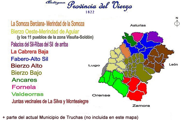
Español: La antigua Provincia del Vierzo (Provincia de El Bierzo) de 1821 (terminada de de limitar en 1822)-1833 . |
| Date | |
| Source | Own work |
| Author | FCPB (Fondo documental de la asociación cultural "Foro Cultural Provincia de El Bierzo") |
Licensing
[edit].JPG&action=edit§ion=2)
| I, the copyright holder of this work, release this work into the public domain. This applies worldwide. In some countries this may not be legally possible; if so: I grant anyone the right to use this work for any purpose, without any conditions, unless such conditions are required by law. |
File history
Click on a date/time to view the file as it appeared at that time.
.JPG&dir=prev)
.JPG&offset=20091108162748)
.JPG&offset=&limit=20)
.JPG&offset=&limit=50)
.JPG&offset=&limit=100)
.JPG&offset=&limit=250)
.JPG&offset=&limit=500)
| Date/Time | Thumbnail | Dimensions | User | Comment | |
|---|---|---|---|---|---|
| current | 16:23, 14 September 2021 | | 748 × 520 (159 KB) | Ramajero (talk | contribs) | Corrijo el archivo ajustándolo a la información que indica, pues ni Laciana ni la parte sur de Valdeorras formaron parte de la provincia del Vierzo, ergo el anterior archivo es incorrecto por falta de rigor en los límites. |
| 21:02, 4 March 2010 |  | 748 × 520 (362 KB) | FCPB (talk | contribs) | Errores en los colores y en la descripción. Mapa correcto con toda la comarca de Valdeorras en el mismo color y O Bolo (color más claro) | |
| 22:58, 21 December 2009 |  | 748 × 520 (251 KB) | FCPB (talk | contribs) | Arreglos menores | |
| 22:52, 21 December 2009 |  | 748 × 520 (76 KB) | FCPB (talk | contribs) | Confusión en imágenes (no coincide el texto con la imagen). Por error se subió una imagen de un mapa que no coincide con el texto. La imagen que se sube ahora si coincide con el texto. | |
| 20:30, 9 November 2009 |  | 748 × 520 (280 KB) | FCPB (talk | contribs) | Mejor calidad de imagen | |
| 20:30, 9 November 2009 |  | 3,300 × 2,473 (635 KB) | FCPB (talk | contribs) | Reverted to version as of 17:23, 9 November 2009 | |
| 17:27, 9 November 2009 |  | 3,300 × 2,473 (634 KB) | FCPB (talk | contribs) | Mejor resolución | |
| 17:23, 9 November 2009 |  | 3,300 × 2,473 (635 KB) | FCPB (talk | contribs) | Descripción más exacta (Trives y O Bolo) | |
| 17:12, 9 November 2009 |  | 4,091 × 3,066 (940 KB) | FCPB (talk | contribs) | Delimitación comarca tradicional Somoza Berciana (por error se había incluido todo el municipio de Villafranca del Bierzo) | |
| 16:27, 8 November 2009 |  | 4,091 × 3,066 (752 KB) | FCPB (talk | contribs) | Cambio de error en la definición de la sprovincias limítrofes |
You cannot overwrite this file.
File usage on Commons
There are no pages that use this file.
File usage on other wikis
The following other wikis use this file:
- Usage on es.wikipedia.org
.JPG&oldid=661656013)