File:Propositions G Dinkel (Schéma La Liberté de l'Est).jpg
Jump to navigation
Jump to search

Size of this preview: 450 × 600 pixels. Other resolutions: 180 × 240 pixels | 360 × 480 pixels | 576 × 768 pixels | 768 × 1,024 pixels | 1,536 × 2,048 pixels | 3,216 × 4,288 pixels.
Original file (3,216 × 4,288 pixels, file size: 6.04 MB, MIME type: image/jpeg)
Captions
Captions
Add a one-line explanation of what this file represents
Summary
[edit].jpg&action=edit§ion=1)
| Description |
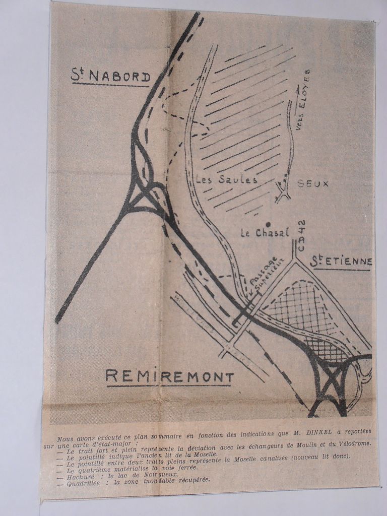
Français : Département des Vosges, « Plan d’eau de Noirgueux », Parc nautique de Remiremont, Plan sommaire exécuté par le quotidien « La Liberté de l’Est », en fonction des indications que Gérard Dinkel ingénieur a reportées sur une carte d’état-major, en complément des études de l’Agence financière de Bassin Rhin-Meuse et de l’Office départemental du tourisme des Vosges.
Légende indiquée par le quotidien « La Liberté de l’Est » :
|
| Date | |
| Source | Quotidien « La Liberté de l’Est », article "RN 66 : une déviation ... une aglomération ... un lac : M. Gérard Dinkel, ingénieur propose" |
| Author | Plan sommaire exécuté par le quotidien « La Liberté de l’Est », en fonction des indications que M. Gérard Dinkel a reportées sur une carte d’état-major |
| Permission (Reusing this file) |
Document diffusé pour l’information du public |
Licensing
[edit].jpg&action=edit§ion=2)
I, the copyright holder of this work, hereby publish it under the following licenses:

|
Permission is granted to copy, distribute and/or modify this document under the terms of the GNU Free Documentation License, Version 1.2 or any later version published by the Free Software Foundation; with no Invariant Sections, no Front-Cover Texts, and no Back-Cover Texts. A copy of the license is included in the section entitled GNU Free Documentation License. |
This file is licensed under the Creative Commons Attribution-Share Alike 3.0 Unported, 2.5 Generic, 2.0 Generic and 1.0 Generic license.
- You are free:
- to share – to copy, distribute and transmit the work
- to remix – to adapt the work
- Under the following conditions:
- attribution – You must give appropriate credit, provide a link to the license, and indicate if changes were made. You may do so in any reasonable manner, but not in any way that suggests the licensor endorses you or your use.
- share alike – If you remix, transform, or build upon the material, you must distribute your contributions under the same or compatible license as the original.
You may select the license of your choice.
File history
Click on a date/time to view the file as it appeared at that time.
| Date/Time | Thumbnail | Dimensions | User | Comment | |
|---|---|---|---|---|---|
| current | 20:03, 3 December 2012 | | 3,216 × 4,288 (6.04 MB) | René Dinkel (talk | contribs) | Meilleure présentation de l'image, et plus grande lisibilité de la légende |
| 20:01, 3 December 2012 |  | 3,216 × 4,288 (6.04 MB) | René Dinkel (talk | contribs) | Meilleure présentation de l'image, et plus grande lisibilité de la légende | |
| 19:23, 3 December 2012 |  | 1,606 × 2,291 (564 KB) | René Dinkel (talk | contribs) | {{Information |Description=Département des Vosges, « Plan d’eau de Noirgueux », Parc nautique de Remiremont, Plan sommaire exécuté par le quotidien « La Liberté de l’Est », en fonction des indications que M. Dinkel a reportées sur une cart... |
You cannot overwrite this file.
File usage on Commons
There are no pages that use this file.
File usage on other wikis
The following other wikis use this file:
- Usage on fr.wikipedia.org
.jpg&oldid=457887891)