File:Proposed site for Metropolitan and St John's Wood Railway's Hampstead station.jpg
Jump to navigation
Jump to search

Size of this preview: 800 × 594 pixels. Other resolutions: 320 × 238 pixels | 640 × 475 pixels | 1,024 × 760 pixels | 1,138 × 845 pixels.
Original file (1,138 × 845 pixels, file size: 790 KB, MIME type: image/jpeg)
Captions
Captions
Add a one-line explanation of what this file represents
Summary
[edit]
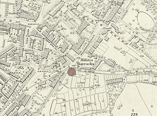
| Description | Map showing approximate location of Metropolitan and St John's Wood Railway's proposed station at Hampstead on 1870 Ordnance Survey map. |
| Date | |
| Source |
Background map: Ordnance Survey map: London VII surveyed 1866, published 1870 |
| Author | DavidCane |
This work is an Ordnance Survey map over 50 years old, which is covered by Crown Copyright which in this case expires 50 years after publication. Ordnance Survey does however ask that they be credited and that the date of publication be given.
Any ancillary rights gained through the creation of the electronic version are granted as freely usable under any circumstances.
|
This work created by the United Kingdom Government is in the public domain.
This is because it is one of the following:
HMSO has declared that the expiry of Crown Copyrights applies worldwide (ref: HMSO Email Reply)
|
 |
This file is licensed under the Creative Commons Attribution 3.0 Unported license.
- You are free:
- to share – to copy, distribute and transmit the work
- to remix – to adapt the work
- Under the following conditions:
- attribution – You must give appropriate credit, provide a link to the license, and indicate if changes were made. You may do so in any reasonable manner, but not in any way that suggests the licensor endorses you or your use.
File history
Click on a date/time to view the file as it appeared at that time.
| Date/Time | Thumbnail | Dimensions | User | Comment | |
|---|---|---|---|---|---|
| current | 16:05, 29 September 2019 | | 1,138 × 845 (790 KB) | DavidCane (talk | contribs) | == {{int:filedesc}} == {{Information |description=Map showing approximate location of Metropolitan and St John's Wood Railway's proposed station at Hampstead on 1870 Ordnance Survey map. |date=2019-09-29 |source=Background map: Ordnance Survey map: London VII surveyed 1866, published 1870<br> Station location as described in Metropolitan and St John's Woo... |
You cannot overwrite this file.
File usage on Commons
There are no pages that use this file.
File usage on other wikis
The following other wikis use this file:
- Usage on en.wikipedia.org