File:Profil ouysse.png
Original file (939 × 439 pixels, file size: 115 KB, MIME type: image/png)
Captions
Captions
Summary
[edit]
| Description |
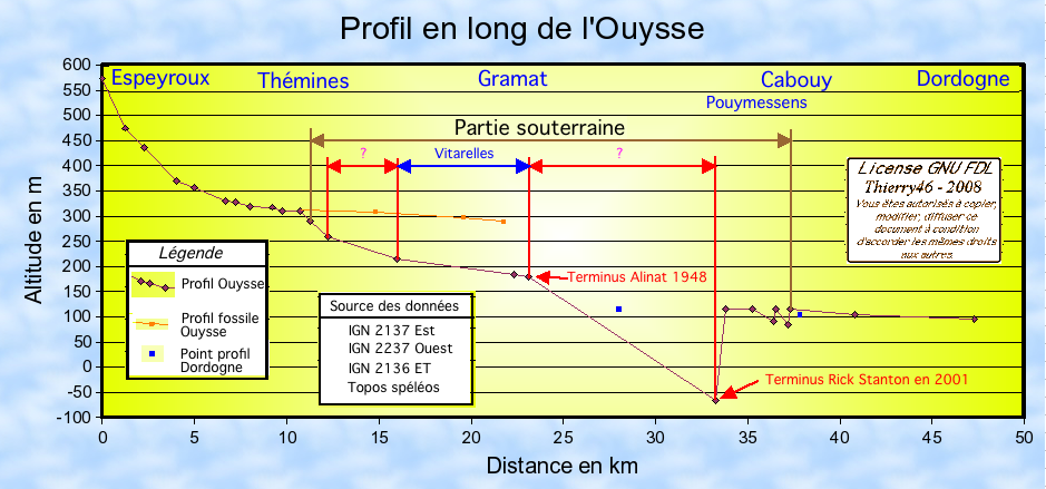
Français : Profil en long de l'Ouysse à partir de la carte IGN et de données topographique Vitarelles. |
| Date | 6/9/2008 |
| Source | Own work |
| Author | Thierry46 |
Lieu Distance en km Altitude en m Pente en pm (m/km) Source 0 574 D205 Espeyroux 1,25 475 79,2 Digue Lasbios 2,25 437 38 Pont Laspergué 4 370 38,29 Conf R Cantegrel 5 357 13 Conf R Cahuac 6,7 331 15,29 Conf R Freysinnet 7,2 327 8 Conf R Lasfargue 8 320 8,75 Conf R Aynac 9,25 318 1,6 Conf R Aynac 9,2 318 0 Pont Tounayne 9,75 311 12,73 Sous Thémines 10,75 310 1 Pertes de Thémines 11,25 290 40 Amont Vitarelles Loze 16 215 15,79 Embarcadère Vitarelles 22,3 185 4,76 Sortie sphon Alinat 23,1 180 6,25 Vasque Cabouy 37,3 115 4,58 Pont D673 Cougnaguet 40,8 105 2,86 Conf Dordogne 47,3 95 1,54
Licensing
[edit]

|
Permission is granted to copy, distribute and/or modify this document under the terms of the GNU Free Documentation License, Version 1.2 or any later version published by the Free Software Foundation; with no Invariant Sections, no Front-Cover Texts, and no Back-Cover Texts. A copy of the license is included in the section entitled GNU Free Documentation License. |
- You are free:
- to share – to copy, distribute and transmit the work
- to remix – to adapt the work
- Under the following conditions:
- attribution – You must give appropriate credit, provide a link to the license, and indicate if changes were made. You may do so in any reasonable manner, but not in any way that suggests the licensor endorses you or your use.
- share alike – If you remix, transform, or build upon the material, you must distribute your contributions under the same or compatible license as the original.
File history
Click on a date/time to view the file as it appeared at that time.
| Date/Time | Thumbnail | Dimensions | User | Comment | |
|---|---|---|---|---|---|
| current | 19:31, 1 October 2008 | | 939 × 439 (115 KB) | Thierry46 (talk | contribs) | |
| 13:30, 7 September 2008 |  | 938 × 439 (104 KB) | Thierry46 (talk | contribs) | ||
| 16:53, 6 September 2008 |  | 936 × 434 (87 KB) | Thierry46 (talk | contribs) | {{Information |Description={{en|1=Altitude of river Ouysse made with IGN and survey from Vitarelles.}} {{fr|1=Profil en long de l'Ouysse à partir de la carte IGN et de données topographique |
You cannot overwrite this file.
File usage on Commons
There are no pages that use this file.
File usage on other wikis
The following other wikis use this file:
- Usage on fr.wikipedia.org