File:Primroses down a pothole - geograph.org.uk - 183086.jpg
Jump to navigation
Jump to search
No higher resolution available.
Primroses_down_a_pothole_-_geograph.org.uk_-_183086.jpg (640 × 480 pixels, file size: 161 KB, MIME type: image/jpeg)
Captions
Captions
Add a one-line explanation of what this file represents
Summary
[edit]
| Description |
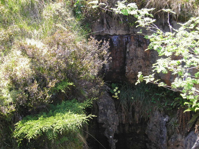
English: Primroses down a pothole. These primroses are growing down Juniper Gulf. There are others further down but poor light and personal safety prevented photographing them.
This pothole is in the middle of a moor (The Allotment) where the vegetation is mainly very rough grass and bog cotton. The exceptions are found in the mouths of potholes where the drainage is better and sheep cannot reach them without falling down the hole (which some do). |
| Date | |
| Source | From geograph.org.uk |
| Author | John Illingworth |
| Attribution (required by the license) | John Illingworth / Primroses down a pothole / |
| Object location | | View this and other nearby images on: OpenStreetMap |
|---|
_heading:270.00&language=en)
Licensing
[edit]

|
This image was taken from the Geograph project collection. See this photograph's page on the Geograph website for the photographer's contact details. The copyright on this image is owned by John Illingworth and is licensed for reuse under the Creative Commons Attribution-ShareAlike 2.0 license.
|
This file is licensed under the Creative Commons Attribution-Share Alike 2.0 Generic license.
Attribution: John Illingworth
- You are free:
- to share – to copy, distribute and transmit the work
- to remix – to adapt the work
- Under the following conditions:
- attribution – You must give appropriate credit, provide a link to the license, and indicate if changes were made. You may do so in any reasonable manner, but not in any way that suggests the licensor endorses you or your use.
- share alike – If you remix, transform, or build upon the material, you must distribute your contributions under the same or compatible license as the original.
- Remove redundant categories and try to put this image in the most specific category/categories
- Remove this template
- The location categories are based on information from this geonames tool and this OpenStreetMap tool combined with a database. You can also have a look at this tool from mysociety.
- The topic category from Geograph was Potholes (caving) (find similar images (caving) at Geograph)
File history
Click on a date/time to view the file as it appeared at that time.
| Date/Time | Thumbnail | Dimensions | User | Comment | |
|---|---|---|---|---|---|
| current | 18:03, 31 January 2010 | | 640 × 480 (161 KB) | GeographBot (talk | contribs) | == {{int:filedesc}} == {{Information |description={{en|1=Primroses down a pothole. These primroses are growing down Juniper Gulf. There are others further down but poor light and personal safety prevented photographing them. This pothole is in the midd |
You cannot overwrite this file.
File usage on Commons
There are no pages that use this file.
File usage on other wikis
The following other wikis use this file:
- Usage on arz.wikipedia.org
- Usage on en.wikipedia.org