File:Prefecturas Napoleonicas 1810.svg
Jump to navigation
Jump to search

Size of this PNG preview of this SVG file: 800 × 566 pixels. Other resolutions: 320 × 226 pixels | 640 × 453 pixels | 1,024 × 724 pixels | 1,280 × 906 pixels | 2,560 × 1,811 pixels.
Original file (SVG file, nominally 800 × 566 pixels, file size: 1.21 MB)
Captions
Captions
Add a one-line explanation of what this file represents
Summary
[edit]
| Description |
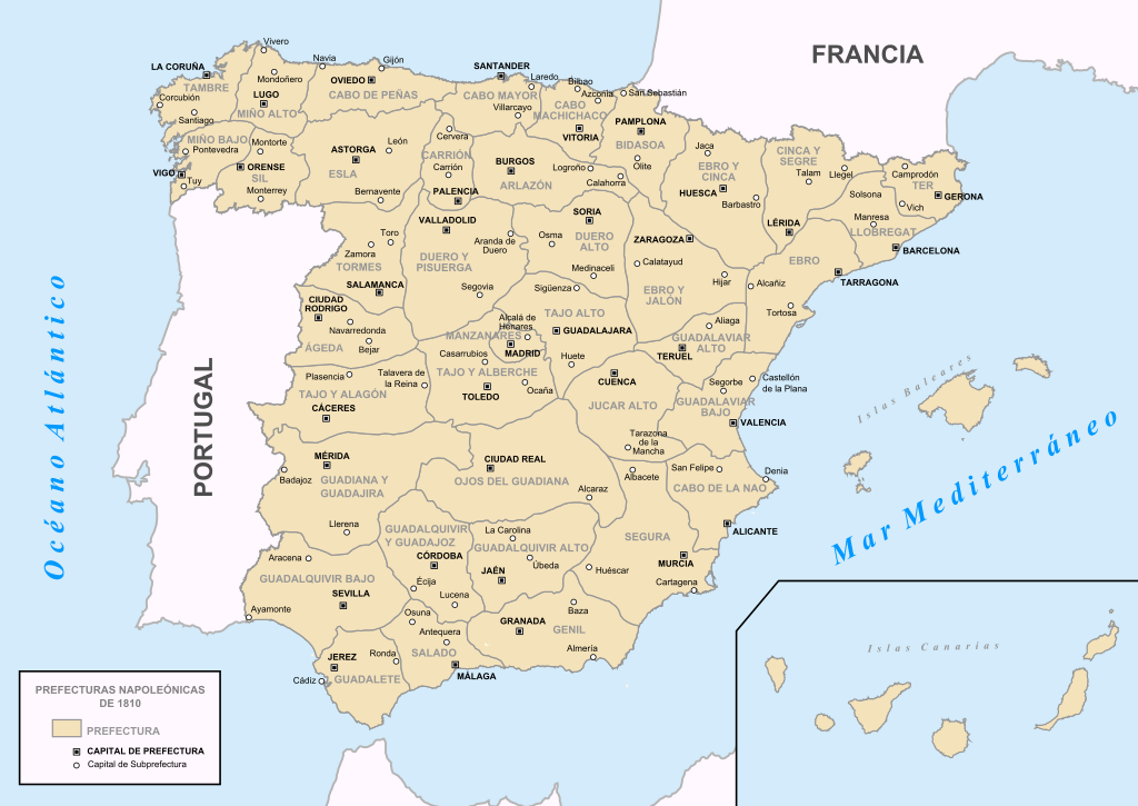
English: Map of napoleonics prefectures of Spain, 1810.
Español: Mapa de las divisiones napoleonicas de España en prefecturas, en 1810. |
| Date | |
| Source |
Own work English: This map is based, modified an extended from File:Provincias de España.svg file (GNU archive) created by Emilio Gómez Fernández and Darz Mol.
Español: Este mapa se ha realizado a partir de File:Provincias de España.svg (archivo con licencia GNU) creado por Emilio Gómez Fernández y Darz Mol. Con las consiguientes modificaciones y extensiones para representar lo descrito. |
| Author | Mao Zaluchi |

|
This SVG file contains embedded text that can be translated into your language, using any capable SVG editor, text editor or the SVG Translate tool. For more information see: About translating SVG files. |
Licensing
[edit]
I, the copyright holder of this work, hereby publish it under the following licenses:

|
Permission is granted to copy, distribute and/or modify this document under the terms of the GNU Free Documentation License, Version 1.2 or any later version published by the Free Software Foundation; with no Invariant Sections, no Front-Cover Texts, and no Back-Cover Texts. A copy of the license is included in the section entitled GNU Free Documentation License. |
| This file is licensed under the Creative Commons Attribution-Share Alike 3.0 Unported license. | ||
| ||
| This licensing tag was added to this file as part of the GFDL licensing update. |
This file is licensed under the Creative Commons Attribution-Share Alike 2.5 Generic, 2.0 Generic and 1.0 Generic license.
- You are free:
- to share – to copy, distribute and transmit the work
- to remix – to adapt the work
- Under the following conditions:
- attribution – You must give appropriate credit, provide a link to the license, and indicate if changes were made. You may do so in any reasonable manner, but not in any way that suggests the licensor endorses you or your use.
- share alike – If you remix, transform, or build upon the material, you must distribute your contributions under the same or compatible license as the original.
You may select the license of your choice.
File history
Click on a date/time to view the file as it appeared at that time.
| Date/Time | Thumbnail | Dimensions | User | Comment | |
|---|---|---|---|---|---|
| current | 14:25, 17 April 2019 | | 800 × 566 (1.21 MB) | Manarejae (talk | contribs) | Reverted to version as of 00:13, 3 December 2015 (UTC) |
| 14:17, 17 April 2019 |  | 800 × 566 (1.21 MB) | Manarejae (talk | contribs) | Montorte corregido por Monforte | |
| 00:13, 3 December 2015 |  | 800 × 566 (1.21 MB) | Ras67 (talk | contribs) | cropped | |
| 16:21, 24 April 2009 |  | 644 × 458 (1.64 MB) | Mao Zaluchi~commonswiki (talk | contribs) | {{Information |Description={{en|1=prueba y subo}} {{es|1=prueba y subo}} |Source=trabajo propio (own work) |Author=Mao Zaluchi |Date=2009-04-27 |Permission= |other_versions= }} <!--{{ImageUpload|full}}--> |
You cannot overwrite this file.
File usage on Commons
There are no pages that use this file.
File usage on other wikis
The following other wikis use this file:
- Usage on an.wikipedia.org
- Usage on ast.wikipedia.org
- Usage on en.wikipedia.org
- Usage on es.wikipedia.org
- Historia de la organización territorial de España
- Región de León
- Guerra de la Independencia en Valladolid
- Configuración histórica de la provincia de Granada
- Prefectura del Guadalete
- Configuración histórica de la provincia de Jaén
- España napoleónica
- Prefectura del Guadalquivir Alto
- Reinado de José I de España
- Corso Terrestre de Navarra
- Usage on fr.wikipedia.org
- Usage on gl.wikipedia.org
- Usage on pt.wikipedia.org