File:Post0037 - Flickr - NOAA Photo Library.jpg

Original file (2,848 × 2,136 pixels, file size: 2.93 MB, MIME type: image/jpeg)
Captions
Captions
Summary
[edit]
| Description |
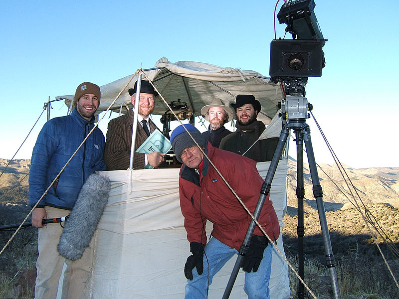
Since late last year NOAA has been filming a 30 minute documentary on the 200 year history of the U.S. Coast and Geodetic Survey (USCGS). The movie is being shot and edited by NOAA’s Ocean Media Center under the direction of film maker and NOAA employee John Brooks. The film is being written and produced by Kate Raisz of 42 Degrees North (commercial film company). In early November, the film team met up with members of NOAA’s National Geodetic Survey (NGS) in southern Utah to shoot a historical reenactment of the transcontinental arc of triangulation survey that was undertaken by members of the USCGS from 1870 to 1900. NGS brought and used a real piece of NOAA history, old “theodolite 188”, the same original piece of equipment that was used during the original survey back in the late 1800s. Inside the tent (from left to right) are NGS employees (and historical reenactors) Joe Evjen, Bill Stone and Casey Brennan. Outside the tent (left to right) are Ocean Media Center employees Paul Hillman and John Brooks. Also visible inside the tent is “old 118”. |
| Date | |
| Source | post0037 |
| Author | NOAA Photo Library |
Licensing
[edit]
- You are free:
- to share – to copy, distribute and transmit the work
- to remix – to adapt the work
- Under the following conditions:
- attribution – You must give appropriate credit, provide a link to the license, and indicate if changes were made. You may do so in any reasonable manner, but not in any way that suggests the licensor endorses you or your use.
| This image was originally posted to Flickr by NOAA Photo Library at https://www.flickr.com/photos/51647007@N08/5143398794. It was reviewed on 3 January 2013 by FlickreviewR and was confirmed to be licensed under the terms of the cc-by-2.0. |
This image is in the public domain because it contains materials that originally came from the U.S. National Oceanic and Atmospheric Administration, taken or made as part of an employee's official duties.
|
File history
Click on a date/time to view the file as it appeared at that time.
| Date/Time | Thumbnail | Dimensions | User | Comment | |
|---|---|---|---|---|---|
| current | 15:07, 7 January 2012 | | 2,848 × 2,136 (2.93 MB) | Kobac (talk | contribs) | {{Information |Description=Since late last year NOAA has been filming a 30 minute documentary on the 200 year history of the U.S. Coast and Geodetic Survey (USCGS). The movie is being shot and edited by NOAA’s Ocean Media Center under the direction of f |
You cannot overwrite this file.
File usage on Commons
There are no pages that use this file.