File:Possible regional languages in regions Ukraine.svg
Jump to navigation
Jump to search

Size of this PNG preview of this SVG file: 800 × 538 pixels. Other resolutions: 320 × 215 pixels | 640 × 431 pixels | 1,024 × 689 pixels | 1,280 × 861 pixels | 2,560 × 1,723 pixels | 1,547 × 1,041 pixels.
Original file (SVG file, nominally 1,547 × 1,041 pixels, file size: 798 KB)
Captions
Captions
Add a one-line explanation of what this file represents
Summary
[edit]
| Description |
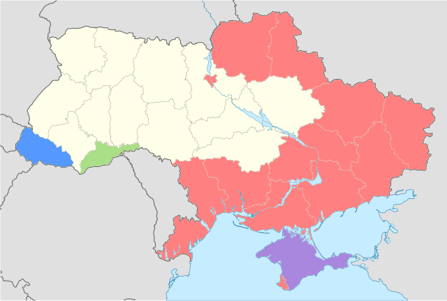
English: Possible regional languages in regions Ukraine Русский: Возможные региональные языки по Закону Украины "Об основах государственной языковой политики"
Русский язык
Русский и крымскотатарские языки
Румынский язык
Венгерский язык |
| Date | (UTC) |
| Source |
This file was derived from: Ukraine location map.svg: |
| Author |
|
| This is a retouched picture, which means that it has been digitally altered from its original version. Modifications: New map. The original can be viewed here: Ukraine location map.svg:
|
Licensing
[edit]
This file is licensed under the Creative Commons Attribution-Share Alike 3.0 Unported license.
- You are free:
- to share – to copy, distribute and transmit the work
- to remix – to adapt the work
- Under the following conditions:
- attribution – You must give appropriate credit, provide a link to the license, and indicate if changes were made. You may do so in any reasonable manner, but not in any way that suggests the licensor endorses you or your use.
- share alike – If you remix, transform, or build upon the material, you must distribute your contributions under the same or compatible license as the original.
Original upload log
[edit]
This image is a derivative work of the following images:
- File:Ukraine_location_map.svg licensed with Cc-by-sa-3.0, GFDL
- 2008-09-26T20:24:51Z NordNordWest 1547x1041 (703516 Bytes)
- 2008-07-24T08:04:06Z NordNordWest 1547x1041 (697990 Bytes) plus Dnieper River
- 2008-07-21T21:24:33Z NordNordWest 1547x1041 (685711 Bytes) {{Information |Description= {{de|Positionskarte der [[:de:Ukraine|Ukraine]]}} Quadratische Plattkarte, N-S-Streckung 150 %. Geographische Begrenzung der Karte: * N: 52.7° N * S: 44.1° N * W: 21.5° O * O: 40.7° O {{en|Loca
File history
Click on a date/time to view the file as it appeared at that time.
| Date/Time | Thumbnail | Dimensions | User | Comment | |
|---|---|---|---|---|---|
| current | 10:21, 16 August 2012 | | 1,547 × 1,041 (798 KB) | Insider (talk | contribs) | == {{int:filedesc}} == {{Information |Description={{en|Possible regional languages in regions Ukraine}}{{ru|Возможные региональные языки по Закону Украины "Об основах государственной яз... |
You cannot overwrite this file.
File usage on Commons
There are no pages that use this file.
File usage on other wikis
The following other wikis use this file:
- Usage on eo.wikinews.org
- Usage on fr.wikinews.org
- Usage on nl.wikinews.org
- Usage on ru.wikipedia.org
- Usage on uk.wikipedia.org
- Користувач:Alex Blokha/Дні згадані в Вікіпедії/Україна/14 травня
- Користувач:Alex Blokha/Дні згадані в Вікіпедії/Україна/22 травня
- Користувач:Alex Blokha/Дні згадані в Вікіпедії/Україна/23 травня
- Користувач:Alex Blokha/Дні згадані в Вікіпедії/Україна/3 липня
- Користувач:Alex Blokha/Дні згадані в Вікіпедії/Україна/4 липня
- Користувач:Alex Blokha/Дні згадані в Вікіпедії/Україна/5 липня
- Користувач:Alex Blokha/Дні згадані в Вікіпедії/Україна/6 липня
- Користувач:Alex Blokha/Дні згадані в Вікіпедії/Україна/8 липня
- Користувач:Alex Blokha/Дні згадані в Вікіпедії/Україна/9 липня
- Користувач:Alex Blokha/Дні згадані в Вікіпедії/Україна/10 липня
- Користувач:Alex Blokha/Дні згадані в Вікіпедії/Україна/13 липня
- Користувач:Alex Blokha/Дні згадані в Вікіпедії/Україна/14 липня
- Користувач:Alex Blokha/Дні згадані в Вікіпедії/Україна/16 липня
- Користувач:Alex Blokha/Дні згадані в Вікіпедії/Україна/17 липня
- Користувач:Alex Blokha/Дні згадані в Вікіпедії/Україна/19 липня
- Користувач:Alex Blokha/Дні згадані в Вікіпедії/Україна/25 липня
- Користувач:Alex Blokha/Дні згадані в Вікіпедії/Україна/27 липня
- Користувач:Alex Blokha/Дні згадані в Вікіпедії/Україна/31 липня
- Користувач:Alex Blokha/Дні згадані в Вікіпедії/Україна/1 серпня
- Користувач:Alex Blokha/Дні згадані в Вікіпедії/Україна/2 серпня
- Користувач:Alex Blokha/Дні згадані в Вікіпедії/Україна/7 серпня
- Користувач:Alex Blokha/Дні згадані в Вікіпедії/Україна/8 серпня
- Користувач:Alex Blokha/Дні згадані в Вікіпедії/Україна/10 серпня
- Користувач:Alex Blokha/Дні згадані в Вікіпедії/Україна/24 серпня
- Користувач:Alex Blokha/Дні згадані в Вікіпедії/Україна/29 серпня
- Користувач:Alex Blokha/Дні згадані в Вікіпедії/Україна/7 вересня
- Закон України «Про засади державної мовної політики»