File:Possible fallen standing stone - geograph.org.uk - 1256900.jpg
Jump to navigation
Jump to search
No higher resolution available.
Possible_fallen_standing_stone_-_geograph.org.uk_-_1256900.jpg (640 × 480 pixels, file size: 86 KB, MIME type: image/jpeg)
Captions
Captions
Add a one-line explanation of what this file represents
Summary
[edit]| Description |
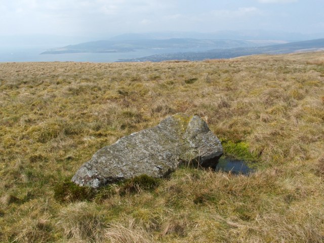
English: Possible fallen standing stone. Although it is now lying prone, this stone may once have stood upright. It is almost two metres long, and is oriented SE to NW (the left and right ends, respectively, in this image); the two exposed faces are very flat in appearance (see 1256913). What may have been the hole in which the stone once stood is visible here, although now filled with water, on the right-hand side. As can also be seen in this image, there is a prominent straight line scored along the near side of the stone.
Further details from WoSAS: http://www.wosas.net/wosas_site.php?id=22274 In the background, the town of Helensburgh is visible on the shore line, although partly hidden by the brow of the hill; further away, on the other side of the Gare Loch, the Rosneath Peninsula can be seen. |
| Date | |
| Source | From geograph.org.uk |
| Author | Lairich Rig |
| Attribution (required by the license) | Lairich Rig / Possible fallen standing stone / |
| Camera location | | View this and other nearby images on: OpenStreetMap |
|---|
| Object location | | View this and other nearby images on: OpenStreetMap |
|---|
Licensing
[edit]
|
This image was taken from the Geograph project collection. See this photograph's page on the Geograph website for the photographer's contact details. The copyright on this image is owned by Lairich Rig and is licensed for reuse under the Creative Commons Attribution-ShareAlike 2.0 license.
|
This file is licensed under the Creative Commons Attribution-Share Alike 2.0 Generic license.
Attribution: Lairich Rig
- You are free:
- to share – to copy, distribute and transmit the work
- to remix – to adapt the work
- Under the following conditions:
- attribution – You must give appropriate credit, provide a link to the license, and indicate if changes were made. You may do so in any reasonable manner, but not in any way that suggests the licensor endorses you or your use.
- share alike – If you remix, transform, or build upon the material, you must distribute your contributions under the same or compatible license as the original.

_heading:270.00&language=en)
_heading:270.00&language=en)
File history
Click on a date/time to view the file as it appeared at that time.
| Date/Time | Thumbnail | Dimensions | User | Comment | |
|---|---|---|---|---|---|
| current | 20:52, 26 February 2011 | | 640 × 480 (86 KB) | GeographBot (talk | contribs) | == {{int:filedesc}} == {{Information |description={{en|1=Possible fallen standing stone Although it is now lying prone, this stone may once have stood upright. It is almost two metres long, and is oriented SE to NW (the left and right ends, respectively, |
You cannot overwrite this file.
File usage on Commons
There are no pages that use this file.