File:Portadown bound train approaching City Hospital station - 1990 (geograph 3794771).jpg
Jump to navigation
Jump to search

Size of this preview: 800 × 572 pixels. Other resolutions: 320 × 229 pixels | 640 × 457 pixels | 893 × 638 pixels.
Original file (893 × 638 pixels, file size: 717 KB, MIME type: image/jpeg)
Captions
Captions
Add a one-line explanation of what this file represents
Summary
[edit].jpg&action=edit§ion=1)
| Description |
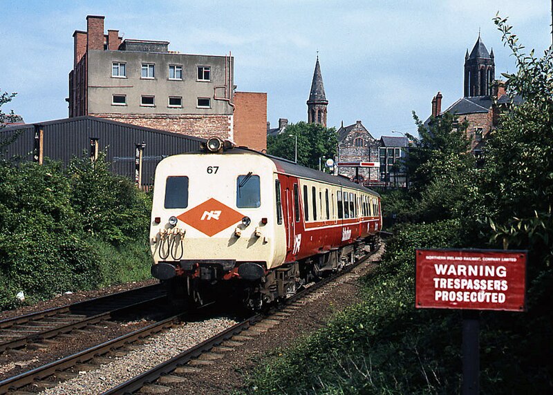
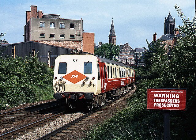
English: Portadown bound train approaching City Hospital station - 1990 Resplendent in full NIR "Suburban" colours, a three-car 80-class set approaches City Hospital station with the 15.50 passenger service from Bangor to Portadown. |
| Date | |
| Source | From geograph.org.uk |
| Author | The Carlisle Kid |
| Permission (Reusing this file) |
Creative Commons Attribution Share-alike license 2.0 |
| Attribution (required by the license) | The Carlisle Kid / Portadown bound train approaching City Hospital station - 1990 / |
| Camera location | | View this and other nearby images on: OpenStreetMap |
|---|
.jpg¶ms=054.588310_N_-005.939039_E_globe:Earth_type:camera_source:geograph-irishgrid(J33287307)_heading:112.00&language=en)
| Object location | | View this and other nearby images on: OpenStreetMap |
|---|
.jpg¶ms=054.588110_N_-005.938120_E_globe:Earth_class:object_type:object_source:geograph-irishgrid(J33347305)_heading:112.00&language=en)
Licensing
[edit].jpg&action=edit§ion=2)

|
This image was taken from the Geograph project collection. See this photograph's page on the Geograph website for the photographer's contact details. The copyright on this image is owned by The Carlisle Kid and is licensed for reuse under the Creative Commons Attribution-ShareAlike 2.0 license.
|
This file is licensed under the Creative Commons Attribution-Share Alike 2.0 Generic license.
Attribution: The Carlisle Kid
- You are free:
- to share – to copy, distribute and transmit the work
- to remix – to adapt the work
- Under the following conditions:
- attribution – You must give appropriate credit, provide a link to the license, and indicate if changes were made. You may do so in any reasonable manner, but not in any way that suggests the licensor endorses you or your use.
- share alike – If you remix, transform, or build upon the material, you must distribute your contributions under the same or compatible license as the original.
File history
Click on a date/time to view the file as it appeared at that time.
| Date/Time | Thumbnail | Dimensions | User | Comment | |
|---|---|---|---|---|---|
| current | 21:11, 13 March 2022 | | 893 × 638 (717 KB) | Lamberhurst (talk | contribs) | == {{int:filedesc}} == {{Information |Description={{en|1=<b>Portadown bound train approaching City Hospital station - 1990</b><br>Resplendent in full NIR "Suburban" colours, a three-car 80-class set approaches City Hospital station with the 15.50 passenger service from Bangor to Portadown.}} |Source=From [https://www.geograph.org.uk/photo/3794771 geograph.org.uk] |Date=1990-04-20 |Author=[https://www.geograph.org.uk/profile/61944 The Carlisle Kid] |Permission=Creative Commons Attribution Shar... |
You cannot overwrite this file.
File usage on Commons
The following page uses this file:
.jpg&oldid=638628022)