File:Port of Aden, Yemen from ISS.jpg
Port_of_Aden,_Yemen_from_ISS.jpg (720 × 480 pixels, file size: 214 KB, MIME type: image/jpeg)
Captions
Captions
| Description |
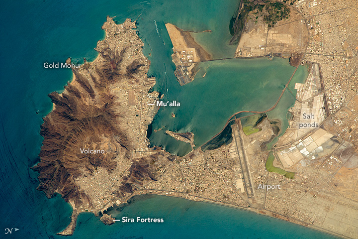
English: Orbiting almost directly over the port of Aden, an astronaut aboard the International Space Station (ISS) took this photograph of the rugged, extinct volcano, the flat sand spit next to it, and the big bay that now all form the port of Aden. Part of the city (just south of the volcano) is known as the Crater neighborhood, and residents can look downhill onto the docks of the old port and the Sira Fortress, an 11th century fortification on a small island just offshore.
The tourist section of Aden is Gold Mohur, which takes advantage of the beaches and surf of this open coastline and the dramatic backdrop of the volcano. On the well-protected bay side of the volcano lies the much larger harbor of Al Mu’alla, the economic hub of Aden. The flat lands of the sand spit are full of salt ponds, where sea water can be evaporated in the near-constant sunshine. Salt production has been a major export from Aden for centuries. The Aden International Airport (formerly the British Royal Air Force station Khormaksar), is Yemen’s second biggest airport. The runways are 3.5 kilometers long (2 miles). The city’s diplomatic missions and the main campus of Aden University surround the airport. Aden lies near the south end of the Red Sea, at a critical point where major sea lanes converge—between Egypt and the Mediterranean Sea, the Persian Gulf and India, and the long shoreline of East Africa. To protect those sea lanes, Great Britain occupied Aden and the surrounding southern parts of the Arabian Peninsula from 1839 to 1967. The small enclave of Djibouti, on the opposite coast in Africa, was held by France for the same reason. |
|||||
| Date | ||||||
| Source | http://earthobservatory.nasa.gov/IOTD/view.php?id=88574&src=eoa-iotd | |||||
| Author | NASA Astronaut photograph ISS047-E-111699 | |||||
| Permission (Reusing this file) |
|

File history
Click on a date/time to view the file as it appeared at that time.
| Date/Time | Thumbnail | Dimensions | User | Comment | |
|---|---|---|---|---|---|
| current | 21:48, 17 August 2016 | | 720 × 480 (214 KB) | Tillman (talk | contribs) | {{Information |Description ={{en|1=Orbiting almost directly over the port of Aden, an astronaut aboard the International Space Station (ISS) took this photograph of the rugged, extinct volcano, the flat sand spit next to it, and the big bay that now... |
You cannot overwrite this file.
File usage on Commons
The following page uses this file:
File usage on other wikis
The following other wikis use this file:
- Usage on azb.wikipedia.org
- Usage on en.wikipedia.org
- Usage on fi.wikipedia.org
- Usage on hu.wikipedia.org
- Usage on id.wikipedia.org
- Usage on mr.wikipedia.org
- Usage on nn.wikipedia.org
- Usage on tl.wikipedia.org
- Usage on vi.wikipedia.org
- Usage on zh.wikipedia.org