File:Port Glasgow town centre - geograph.org.uk - 1610092.jpg
Jump to navigation
Jump to search
No higher resolution available.
Port_Glasgow_town_centre_-_geograph.org.uk_-_1610092.jpg (640 × 431 pixels, file size: 62 KB, MIME type: image/jpeg)
Captions
Captions
Add a one-line explanation of what this file represents
Summary
[edit]
| Description |
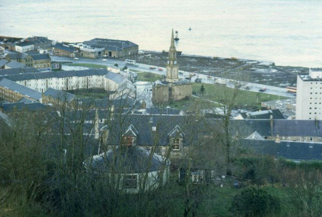
English: Port Glasgow town centre. A scanned photograph, taken from Dougliehill Terrace around 1985. Coronation Park, by the river, is completely cleared to have new drainage added to what was previously dockland. Perch Lighthouse, the old warehouses at West Quay and the Town Building (before it was extended) can also be seen.
Amongst the trees in the foreground is a small round dwellinghouse which stood at Roseyard. The building was destroyed by fire not long after this photo was taken. Roseyard Place 1600158 now stands on the site. |
| Date | |
| Source | From geograph.org.uk |
| Author | Thomas Nugent |
| Attribution (required by the license) | Thomas Nugent / Port Glasgow town centre / |
| Camera location | | View this and other nearby images on: OpenStreetMap |
|---|
_heading:0.00&language=en)
| Object location | | View this and other nearby images on: OpenStreetMap |
|---|
_heading:0.00&language=en)
Licensing
[edit]

|
This image was taken from the Geograph project collection. See this photograph's page on the Geograph website for the photographer's contact details. The copyright on this image is owned by Thomas Nugent and is licensed for reuse under the Creative Commons Attribution-ShareAlike 2.0 license.
|
This file is licensed under the Creative Commons Attribution-Share Alike 2.0 Generic license.
Attribution: Thomas Nugent
- You are free:
- to share – to copy, distribute and transmit the work
- to remix – to adapt the work
- Under the following conditions:
- attribution – You must give appropriate credit, provide a link to the license, and indicate if changes were made. You may do so in any reasonable manner, but not in any way that suggests the licensor endorses you or your use.
- share alike – If you remix, transform, or build upon the material, you must distribute your contributions under the same or compatible license as the original.
File history
Click on a date/time to view the file as it appeared at that time.
| Date/Time | Thumbnail | Dimensions | User | Comment | |
|---|---|---|---|---|---|
| current | 10:31, 4 March 2011 | | 640 × 431 (62 KB) | GeographBot (talk | contribs) | == {{int:filedesc}} == {{Information |description={{en|1=Port Glasgow town centre A scanned photograph, taken from Dougliehill Terrace around 1985. Coronation Park, by the river, is completely cleared to have new drainage added to what was previously doc |
You cannot overwrite this file.
File usage on Commons
There are no pages that use this file.