File:Population development Kreis Minden.png
Jump to navigation
Jump to search
No higher resolution available.
Population_development_Kreis_Minden.png (753 × 431 pixels, file size: 23 KB, MIME type: image/png)
Captions
Captions
Add a one-line explanation of what this file represents
Summary
[edit]
| Description |
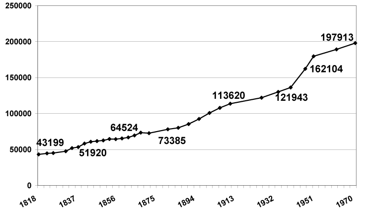
English: population development in former County of Minden (Westfalen), Germany
Deutsch: Bevölkerungsentwicklung im früheren Kreis Minden (Westfalen), Deutschland |
| Date | 3 July 2008 (upload date) |
| Source | Own work |
| Author | Hagar66 |
| Object location | | View this and other nearby images on: OpenStreetMap |
|---|
Licensing
[edit]
| I, the copyright holder of this work, release this work into the public domain. This applies worldwide. In some countries this may not be legally possible; if so: I grant anyone the right to use this work for any purpose, without any conditions, unless such conditions are required by law. |

|
File:Kreis Minden - population development.svg is a vector version of this file. It should be used in place of this PNG file when not inferior.
File:Population development Kreis Minden.png → File:Kreis Minden - population development.svg
For more information, see Help:SVG. |
 |
File history
Click on a date/time to view the file as it appeared at that time.
| Date/Time | Thumbnail | Dimensions | User | Comment | |
|---|---|---|---|---|---|
| current | 12:42, 3 July 2008 | | 753 × 431 (23 KB) | Hagar66 (talk | contribs) | {{Information |Description={{en|1=population development in former County of Minden (Westfalen), Germany}} {{de|1=Bevölkerungsentwicklung im früheren Kreis Minden (Westfalen), Deutschland}} |Source=Eigenes Werk (own work) |Author=[[User:Hagar66|Hagar66] |
You cannot overwrite this file.
File usage on Commons
There are no pages that use this file.