File:Ponton Latécoère St-Laurent-de-la-Salanque.jpg

Original file (4,608 × 3,456 pixels, file size: 5.15 MB, MIME type: image/jpeg)
Captions
Captions
Summary
[edit]
| Description |
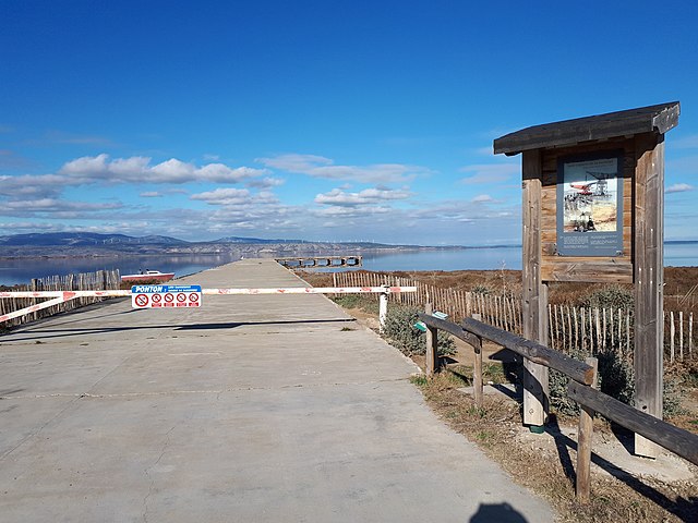
Français : Le ponton Latécoère de St-Laurent-de-la-Salanque, Pyrénées-Orientales, 66.
Texte sur le panneau explicatif : « Base Latécoère 1925-1936. Mise à l'eau d'un LATE 28 (1930). En choisissant d'implanter une base d'essai d'hydroavions sur la façade maritime de Saint-Laurent de la Salanque, Pierre-Georges Latécoère, créateur de la poste aérienne transcontinentale, a permis d'associer notre ville à une des plus belles aventures humaines du XXème siècle. C'est d'ici notamment que décolleront pour la première fois le mythique "LATE 28 - comte de la Vaulx" et de nombreux pilotes dont Jean Mermoz et Antoine Saint-Exupéry. Le ponton long de 130 mètres, sur laquel se dressait autrefois une grue, témoigne de ce glorieux passé historique. Alain Got Maire de Saint-Laurent de la Salanque » Le ponton Latécoére est l'unique vestige de cette base d'essai d'hydroavions. C'est ici, sur près de 150 hectares, que l'industriel Pierre-Georges Latécoère implante sa base d'essais en 1925 pour assembler et tester les hydravions construits à Toulouse. Le site est composé de hangars et ateliers, d'une base météorologique, d'un poste TSE, de bureaux et logements, d'un aérodrome, d'un ponton en béton long de 130 m et d'une grue géante pour tirer les hydravioms hors de l'étang. La base a servi de relais sur le trajet de la ligne aéropostale Europe — Amérique du Sud, la plus longue ligne aérienne du monde de l'époque. En 1937, le site est vendu à l'Armée française et devient une base d'entrainement. |
| Date | |
| Source | Own work |
| Author | Alan Mattingly |
| Camera location | | View this and other nearby images on: OpenStreetMap |
|---|
Licensing
[edit]
- You are free:
- to share – to copy, distribute and transmit the work
- to remix – to adapt the work
- Under the following conditions:
- attribution – You must give appropriate credit, provide a link to the license, and indicate if changes were made. You may do so in any reasonable manner, but not in any way that suggests the licensor endorses you or your use.
- share alike – If you remix, transform, or build upon the material, you must distribute your contributions under the same or compatible license as the original.
File history
Click on a date/time to view the file as it appeared at that time.
| Date/Time | Thumbnail | Dimensions | User | Comment | |
|---|---|---|---|---|---|
| current | 16:39, 6 January 2023 | | 4,608 × 3,456 (5.15 MB) | Alan Mattingly (talk | contribs) | Uploaded own work with UploadWizard |
You cannot overwrite this file.
File usage on Commons
The following page uses this file:
File usage on other wikis
The following other wikis use this file:
- Usage on fr.wikipedia.org