File:Ponte Santo Hilário.jpg
Jump to navigation
Jump to search

Size of this preview: 800 × 450 pixels. Other resolutions: 320 × 180 pixels | 640 × 360 pixels | 1,024 × 576 pixels | 1,280 × 720 pixels | 2,560 × 1,441 pixels | 4,208 × 2,368 pixels.
Original file (4,208 × 2,368 pixels, file size: 2.34 MB, MIME type: image/jpeg)
Captions
Captions
Add a one-line explanation of what this file represents
Summary
[edit]
| Description |
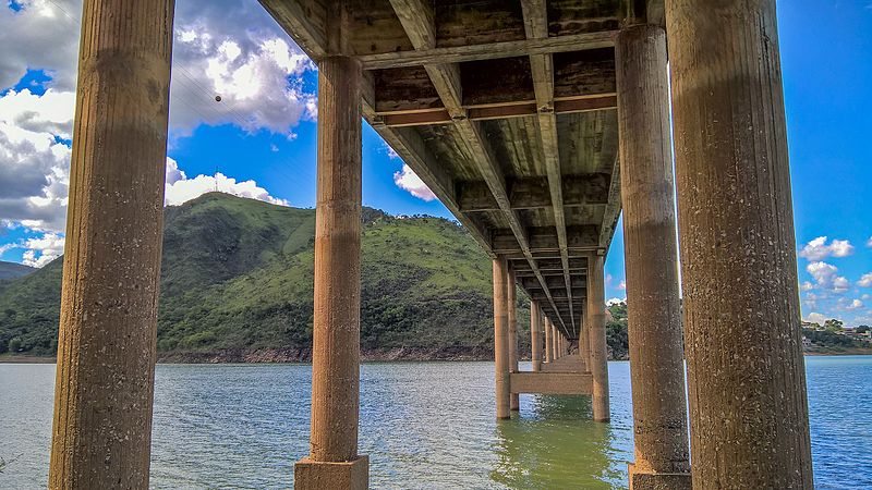
Português: A ponte fica numa vila de mesmo nome e conta com menos de 100 habitantes e fica situada as margens do lago da represa de Furnas. Foi elevada a distrito do município de Piumhi em 19 de dezembro de 1896, com o nome de Bocaina de Minas, e teve seu nome alterado para Santo Hilário em homenagem ao francês Auguste de Saint-Hilaire, por decreto em 7 de setembro de 1923, tendo sido transferida ao município de Pimenta quando da sua emancipação, em 4 de abril de 1946. Também chamada de Capetinga, nome do porto fluvial (Porto Capetinga) e do ribeirão que passava por la e desaguava no rio Grande (Ribeirão Capetinga), por seus antigos moradores, pode ter nascido como São Sebastião do Rio Grande, em homenagem ao padroeiro, São Sebastião. A vila foi quase toda submersa pelo lago da represa de Furnas, restando somente o cemitério. Importante porto do Rio Grande, último da parte navegável do rio, que ligava a estrada de ferro que vinha do Rio de Janeiro até a cidade de Ribeirão Vermelho, o primeiro porto ao sertão. Serviu de entreposto de mercadorias que vinham de trem e depois de barco para o Centro-Oeste e produtos agropecuários do Centro-Oeste para o Rio de Janeiro. Com grande vocação para o turismo, a vila renasceu e hoje fica espremida entre a montanha e a represa.
English: The bridge is located in a village of the same name and has less than 100 inhabitants and is situated on the banks Furnas Dam Lake. Was elevated to Piumhi county district on December 19, 1896, with the name of Bocaina de Minas, and changed its name to St. Hilary after the French Auguste de Saint-Hilaire, by decree on September 7, 1923, having been transferred to pepper the municipality when its emancipation, on April 4, 1946. also called Capel, name the river port (porto Capel) and the creek that ran by her and emptied into the Rio Grande (Ribeirão Capetinga), by its former residents may have been born as Sao Sebastiao do Rio Grande, in honor of the patron saint, San Sebastian. The village was almost all submerged by the lake of Furnas dam, leaving only the cemetery. Important port of Rio Grande, the last navigable part of the river, connecting the railroad coming from Rio de Janeiro to the city of Ribeirão Vermelho, the first port to the hinterland. He served as storage of goods coming by train and then by boat to the Midwest and agricultural products from the Midwest to Rio de Janeiro. With great vocation for tourism, the village has been reborn and is now squeezed between the mountain and the dam. |
| Date | |
| Source | Own work |
| Author | Matheus Soares Costa |
| Camera location | | View this and other nearby images on: OpenStreetMap |
|---|
Licensing
[edit]
I, the copyright holder of this work, hereby publish it under the following license:
This file is licensed under the Creative Commons Attribution-Share Alike 4.0 International license.
- You are free:
- to share – to copy, distribute and transmit the work
- to remix – to adapt the work
- Under the following conditions:
- attribution – You must give appropriate credit, provide a link to the license, and indicate if changes were made. You may do so in any reasonable manner, but not in any way that suggests the licensor endorses you or your use.
- share alike – If you remix, transform, or build upon the material, you must distribute your contributions under the same or compatible license as the original.
This image was uploaded as part of Wiki Loves Earth 2016.
|
 |
File history
Click on a date/time to view the file as it appeared at that time.
| Date/Time | Thumbnail | Dimensions | User | Comment | |
|---|---|---|---|---|---|
| current | 01:38, 7 June 2016 | | 4,208 × 2,368 (2.34 MB) | Matheussc1 (talk | contribs) | User created page with UploadWizard |
You cannot overwrite this file.
File usage on Commons
There are no pages that use this file.