File:Ponta Porã in Brazil (1943).svg
Jump to navigation
Jump to search

Size of this PNG preview of this SVG file: 606 × 600 pixels. Other resolutions: 243 × 240 pixels | 485 × 480 pixels | 776 × 768 pixels | 1,035 × 1,024 pixels | 2,070 × 2,048 pixels | 2,008 × 1,987 pixels.
Original file (SVG file, nominally 2,008 × 1,987 pixels, file size: 1.36 MB)
Captions
Captions
Add a one-line explanation of what this file represents
Summary
[edit].svg&action=edit§ion=1)
| Description |
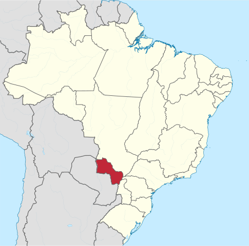
Español: Localización del territorio federal de Punta Porá en los Estados Unidos del Brasil (1943)
English: Map indicating the former Federal Territory of Ponta Porã, in the United States of Brazil (1943).
Português: Mapa indicando a antigo Território Federal de Ponta Porã, no território do Estados Unidos do Brasil (1943). |
| Date | |
| Source | Own work |
| Author | Milenioscuro |
Licensing
[edit].svg&action=edit§ion=2)
I, the copyright holder of this work, hereby publish it under the following license:
This file is licensed under the Creative Commons Attribution-Share Alike 4.0 International license.
- You are free:
- to share – to copy, distribute and transmit the work
- to remix – to adapt the work
- Under the following conditions:
- attribution – You must give appropriate credit, provide a link to the license, and indicate if changes were made. You may do so in any reasonable manner, but not in any way that suggests the licensor endorses you or your use.
- share alike – If you remix, transform, or build upon the material, you must distribute your contributions under the same or compatible license as the original.
File history
Click on a date/time to view the file as it appeared at that time.
| Date/Time | Thumbnail | Dimensions | User | Comment | |
|---|---|---|---|---|---|
| current | 19:59, 7 March 2019 | | 2,008 × 1,987 (1.36 MB) | Milenioscuro (talk | contribs) | +rivers |
| 00:05, 12 December 2015 |  | 2,008 × 1,984 (1.85 MB) | Milenioscuro (talk | contribs) | User created page with UploadWizard |
You cannot overwrite this file.
File usage on Commons
The following page uses this file:
- File:Brazil - Ponta Porã (1943).svg (file redirect)
.svg&redirect=no)
File usage on other wikis
The following other wikis use this file:
- Usage on en.wikipedia.org
- Usage on es.wikipedia.org
- Usage on pt.wikipedia.org
.svg&oldid=747425464)