File:Pons Cestius, Fields of Mars (Campus Martius), Rome (9102116394).jpg

Original file (4,288 × 3,216 pixels, file size: 5.82 MB, MIME type: image/jpeg)
Captions
Captions
Summary
[edit],_Rome_(9102116394).jpg&action=edit§ion=1)
| Description |
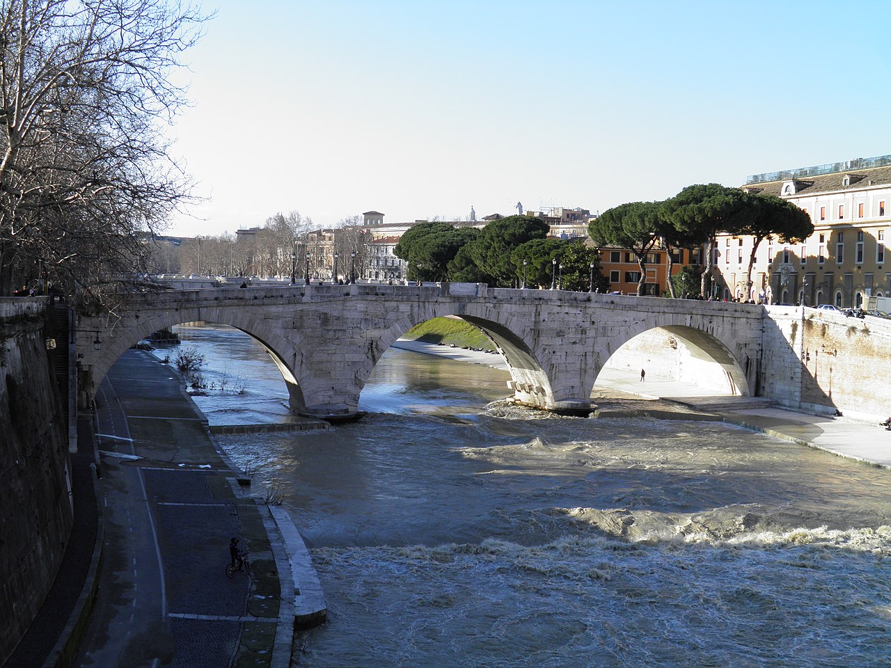
The Pons Cestius (Italian: Ponte Cestio, meaning "Cestius' Bridge") is a Roman stone bridge in Rome, Italy, spanning the Tiber to the west of the Tiber Island. The original version of this bridge was built around the 1st century BC (some time between 62 and 27 BC), after the Pons Fabricius, sited on the other side of island. Both the pontes Cestius and Fabricius were long-living bridges; however, whereas the Fabricius remains wholly intact, the Ponte Cestio was partly dismantled in the 19th century, with only some of the ancient structure preserved. The Pons Cestius is the first bridge that reached the right bank of Tiber from the Tiber Island. Whereas the island was long connected with the left bank of the Tiber and the heart of ancient Rome, even before the pons Fabricius, the right bank (Transtiber) remained unconnected until the Cestius was constructed. Several prominent members of the Cestii clan from the 1st century BC are known, but it is uncertain which of them built this bridge. In the 4th century the Pons Cestius was rebuilt by the Emperors Valentinian I, Valens and Gratian and re-dedicated in 370 as the Pons Gratiani. The bridge was rebuilt using tuff and peperino, with a facing of travertine. Some of the rebuilding material came from the demolished porticus of the nearby Theatre of Marcellus. During the building of the walls along the river embankment in 1888–1892, the bridge had to be demolished and rebuilt, as the western channel was widened from 48 to 76 meters. The ancient bridge, which had two small arches, was simply not long enough. A new bridge, with three large arches, was constructed in its stead, with its central arch reusing about two-thirds of the original material. |
| Date | |
| Source |
Pons Cestius, Fields of Mars (Campus Martius), Rome
|
| Author | Carole Raddato from FRANKFURT, Germany |
| Camera location | | View this and other nearby images on: OpenStreetMap |
|---|
,_Rome_(9102116394).jpg¶ms=041.890952_N_0012.474353_E_globe:Earth_type:camera_source:Flickr_&language=en)
Licensing
[edit],_Rome_(9102116394).jpg&action=edit§ion=2)
- You are free:
- to share – to copy, distribute and transmit the work
- to remix – to adapt the work
- Under the following conditions:
- attribution – You must give appropriate credit, provide a link to the license, and indicate if changes were made. You may do so in any reasonable manner, but not in any way that suggests the licensor endorses you or your use.
- share alike – If you remix, transform, or build upon the material, you must distribute your contributions under the same or compatible license as the original.
| This image, originally posted to Flickr, was reviewed on 14 December 2013 by the administrator or reviewer File Upload Bot (Magnus Manske), who confirmed that it was available on Flickr under the stated license on that date. |
File history
Click on a date/time to view the file as it appeared at that time.
| Date/Time | Thumbnail | Dimensions | User | Comment | |
|---|---|---|---|---|---|
| current | 15:24, 14 December 2013 | | 4,288 × 3,216 (5.82 MB) | File Upload Bot (Magnus Manske) (talk | contribs) | Transferred from Flickr by User:Marcus Cyron |
You cannot overwrite this file.
File usage on Commons
There are no pages that use this file.
,_Rome_(9102116394).jpg&oldid=757210632)