File:Ponies at Mount Misery - geograph.org.uk - 1500906.jpg
Jump to navigation
Jump to search
No higher resolution available.
Ponies_at_Mount_Misery_-_geograph.org.uk_-_1500906.jpg (640 × 480 pixels, file size: 106 KB, MIME type: image/jpeg)
Captions
Captions
Add a one-line explanation of what this file represents
Summary
[edit]
| Description |
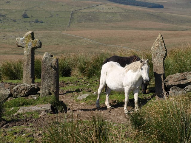
English: Ponies at Mount Misery. Another view of the cross and gateposts shown in 23374. "One of a number of crosses that marks the route of the Monks' Path. This is the ancient name given to the track that links the Buckfast Abbey with those at Tavistock and Buckland. This path takes a more northerly route than the more commonly known Abbots' Way ... William Crossing reports that, in the summer of 1878, this cross was lying flat on the ground. When he visited it again in 1879 it had been re-erected, but by 1885 it was once more found lying on the ground. It was again re-erected in 1885 by the Dartmoor Preservation Society, ably assisted by William Crossing, and has remained in place ever since" http://www.dartmoor-crosses.org.uk/mount_misery.htm . |
| Date | |
| Source | From geograph.org.uk |
| Author | Derek Harper |
| Attribution (required by the license) | Derek Harper / Ponies at Mount Misery / |
| Camera location | | View this and other nearby images on: OpenStreetMap |
|---|
_heading:292.00&language=en)
| Object location | | View this and other nearby images on: OpenStreetMap |
|---|
_heading:292.00&language=en)
Licensing
[edit]

|
This image was taken from the Geograph project collection. See this photograph's page on the Geograph website for the photographer's contact details. The copyright on this image is owned by Derek Harper and is licensed for reuse under the Creative Commons Attribution-ShareAlike 2.0 license.
|
This file is licensed under the Creative Commons Attribution-Share Alike 2.0 Generic license.
Attribution: Derek Harper
- You are free:
- to share – to copy, distribute and transmit the work
- to remix – to adapt the work
- Under the following conditions:
- attribution – You must give appropriate credit, provide a link to the license, and indicate if changes were made. You may do so in any reasonable manner, but not in any way that suggests the licensor endorses you or your use.
- share alike – If you remix, transform, or build upon the material, you must distribute your contributions under the same or compatible license as the original.
File history
Click on a date/time to view the file as it appeared at that time.
| Date/Time | Thumbnail | Dimensions | User | Comment | |
|---|---|---|---|---|---|
| current | 21:23, 2 March 2011 | | 640 × 480 (106 KB) | GeographBot (talk | contribs) | == {{int:filedesc}} == {{Information |description={{en|1=Ponies at Mount Misery Another view of the cross and gateposts shown in 23374. "One of a number of crosses that marks the route of the Monks Path. This is the ancient name given to the track t |
You cannot overwrite this file.
File usage on Commons
There are no pages that use this file.