File:Pondfield Cove and Worbarrow Tout - geograph.org.uk - 645563.jpg
Jump to navigation
Jump to search
No higher resolution available.
Pondfield_Cove_and_Worbarrow_Tout_-_geograph.org.uk_-_645563.jpg (640 × 480 pixels, file size: 96 KB, MIME type: image/jpeg)
Captions
Captions
Add a one-line explanation of what this file represents
Summary
[edit]
| Description |
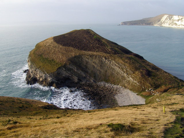
English: Pondfield Cove and Worbarrow Tout Looking down into Pondfield Cove from the cliff path at Worbarrow. The isthmus beyond is called Worbarrow Tout - "tout" meaning lookout place. The northwards dip of the rock strata is obvious in the west and east cliffs of the cove.
The cove itself has formed as the sea has nibbled along a north-south fault. The origins of the gap are still debated - see Ian West's excellent Geology of the Wessex Coast website: http://www.soton.ac.uk/~imw/worbar.htm#streams . Eventually the sea will break through the gap to Worbarrow Beach on the far side, leaving Worbarrow Tout as an island - a larger version of the Mupe Rocks on the far side of the bay (just about visible in the distance). The Isle of Portland is just visible in the hazy far distance. The concrete blocks at the head of the cove are anti-tank defences, relics from the Second World War. |
| Date | |
| Source | From geograph.org.uk |
| Author | Jim Champion |
| Attribution (required by the license) | Jim Champion / Pondfield Cove and Worbarrow Tout / |
| Camera location | | View this and other nearby images on: OpenStreetMap |
|---|
_heading:247.00&language=en)
| Object location | | View this and other nearby images on: OpenStreetMap |
|---|
_heading:247.00&language=en)
Licensing
[edit]

|
This image was taken from the Geograph project collection. See this photograph's page on the Geograph website for the photographer's contact details. The copyright on this image is owned by Jim Champion and is licensed for reuse under the Creative Commons Attribution-ShareAlike 2.0 license.
|
This file is licensed under the Creative Commons Attribution-Share Alike 2.0 Generic license.
Attribution: Jim Champion
- You are free:
- to share – to copy, distribute and transmit the work
- to remix – to adapt the work
- Under the following conditions:
- attribution – You must give appropriate credit, provide a link to the license, and indicate if changes were made. You may do so in any reasonable manner, but not in any way that suggests the licensor endorses you or your use.
- share alike – If you remix, transform, or build upon the material, you must distribute your contributions under the same or compatible license as the original.
File history
Click on a date/time to view the file as it appeared at that time.
| Date/Time | Thumbnail | Dimensions | User | Comment | |
|---|---|---|---|---|---|
| current | 19:28, 11 March 2011 | | 640 × 480 (96 KB) | GeographBot (talk | contribs) | == {{int:filedesc}} == {{Information |description={{en|1=Pondfield Cove and Worbarrow Tout Looking down into Pondfield Cove from the cliff path at Worbarrow. The isthmus beyond is called Worbarrow Tout - "tout" meaning lookout place. The northwards dip of |
You cannot overwrite this file.
File usage on Commons
There are no pages that use this file.