File:Poltavska gubernia povity stany 1859.jpg
Jump to navigation
Jump to search

Size of this preview: 800 × 597 pixels. Other resolutions: 320 × 239 pixels | 640 × 478 pixels | 1,024 × 764 pixels | 1,280 × 955 pixels | 2,560 × 1,911 pixels | 8,943 × 6,675 pixels.
Original file (8,943 × 6,675 pixels, file size: 3.63 MB, MIME type: image/jpeg)
Captions
Captions
Add a one-line explanation of what this file represents
Summary
[edit]
| Warning | The original file is very high-resolution. It might not load properly or could cause your browser to freeze when opened at full size. |
|---|
| Description |
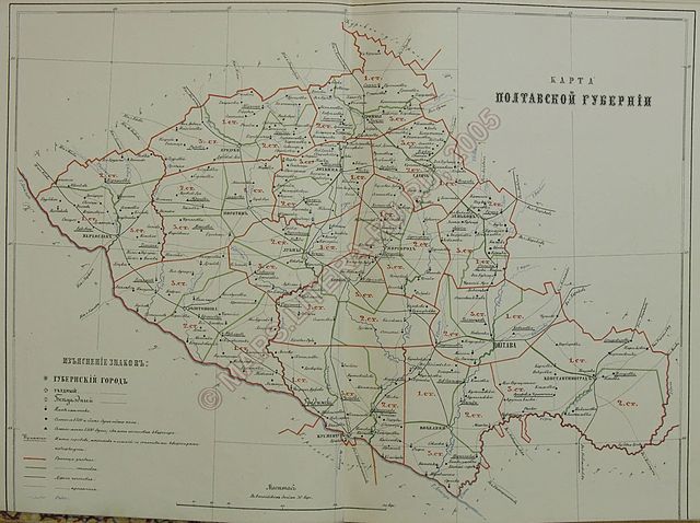
English: Map of Poltava province (up to 1862) Українська: Мапа Полтавської губернії (не пізніше 1862 року). Полтавська губернія з поділом на повіти та стани |
| Date | не пізніше 1862 |
| Source | Списки населенных мест Российской империи. Т.XXXIII. Полтавская губерния. По сведениям 1859 года. — Санктпетербург, 1862 |
| Author | Unknown author |
Licensing
[edit]
|
This work is in the public domain in its country of origin and other countries and areas where the copyright term is the author's life plus 70 years or fewer. | |
| This file has been identified as being free of known restrictions under copyright law, including all related and neighboring rights. | |
Original upload log
[edit]
The original description page was here. All following user names refer to uk.wikipedia.
- 2010-10-19 17:02 Pvladko 8943×6675× (3807611 bytes) {{Зображення |Назва=Мара Полтавської губернії (не пізніше 1862 року) |Опис=Полтавська губернія з поділом на повіти та стани. |Автор=Невідомий |Д
File history
Click on a date/time to view the file as it appeared at that time.
| Date/Time | Thumbnail | Dimensions | User | Comment | |
|---|---|---|---|---|---|
| current | 14:58, 25 January 2013 | | 8,943 × 6,675 (3.63 MB) | Pvladko (talk | contribs) | {{Information |Description={{uk|== Ліцензування ==}} |Source=Transferred from [http://uk.wikipedia.org uk.wikipedia] |Date={{Original upload date|2010-10-19}} |Author=Original uploader was {{user at project|Pvladko|wikipedia|uk}} |Permissio... |
You cannot overwrite this file.
File usage on Commons
There are no pages that use this file.
File usage on other wikis
The following other wikis use this file:
- Usage on uk.wikipedia.org