File:Political map of Africa - DPLA - 8e5c05fd88c744e3c33338ac2aa18a5c.jpg
Jump to navigation
Jump to search

Size of this preview: 574 × 600 pixels. Other resolutions: 230 × 240 pixels | 459 × 480 pixels | 958 × 1,001 pixels.
Original file (958 × 1,001 pixels, file size: 221 KB, MIME type: image/jpeg)
Captions
Captions
Add a one-line explanation of what this file represents
Summary
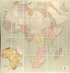
[edit]| Political map of Africa
( |
|||||||||||||||||||||
|---|---|---|---|---|---|---|---|---|---|---|---|---|---|---|---|---|---|---|---|---|---|
| Creator | Bartholomew, J. G. (John George), 1860-1920 | ||||||||||||||||||||
| Title |
Political map of Africa |
||||||||||||||||||||
| Description |
1:12,000,000 |
||||||||||||||||||||
| Date | 1890 | ||||||||||||||||||||
| Collection |
|
||||||||||||||||||||
| Source/Photographer |
|
||||||||||||||||||||
| Permission (Reusing this file) |
|
||||||||||||||||||||
| Standardized rights statement |
|
||||||||||||||||||||


File history
Click on a date/time to view the file as it appeared at that time.
| Date/Time | Thumbnail | Dimensions | User | Comment | |
|---|---|---|---|---|---|
| current | 08:44, 4 November 2022 | | 958 × 1,001 (221 KB) | DPLA bot (talk | contribs) | Uploading DPLA ID 8e5c05fd88c744e3c33338ac2aa18a5c |
You cannot overwrite this file.
File usage on Commons
The following page uses this file: