File:Political divisions of Mexico 1824 (location map scheme).svg
Jump to navigation
Jump to search

Size of this PNG preview of this SVG file: 631 × 600 pixels. Other resolutions: 252 × 240 pixels | 505 × 480 pixels | 808 × 768 pixels | 1,077 × 1,024 pixels | 2,154 × 2,048 pixels | 649 × 617 pixels.
Original file (SVG file, nominally 649 × 617 pixels, file size: 509 KB)
Captions
Captions
Add a one-line explanation of what this file represents
Summary
[edit].svg&action=edit§ion=1)
| Description |
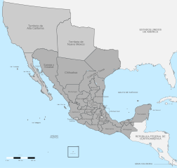
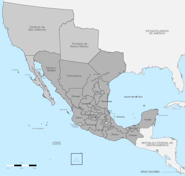
English: Political divisions of independent México in 1824, in the present day U.S. and México.
Federal territory
Sovereign state Español: División política de México 1824.
Territorio federal
Estado soberano |
| Date | |
| Source | Instituto Nacional de Estadística y Geografía (INEGI) |
| Author | Giggette |
| SVG development | |
| Attribution (required by the license) | © Giggette / Wikimedia Commons / |
| Camera location | | View this and other nearby images on: OpenStreetMap |
|---|
.svg¶ms=019.409500_N_-099.130700_E_globe:Earth_type:camera_type:satellite_region:MX_heading:0.00&language=en)
Licensing
[edit].svg&action=edit§ion=2)
I, the copyright holder of this work, hereby publish it under the following licenses:
This file is licensed under the Creative Commons Attribution-Share Alike 3.0 Unported license.
- You are free:
- to share – to copy, distribute and transmit the work
- to remix – to adapt the work
- Under the following conditions:
- attribution – You must give appropriate credit, provide a link to the license, and indicate if changes were made. You may do so in any reasonable manner, but not in any way that suggests the licensor endorses you or your use.
- share alike – If you remix, transform, or build upon the material, you must distribute your contributions under the same or compatible license as the original.

|
Permission is granted to copy, distribute and/or modify this document under the terms of the GNU Free Documentation License, Version 1.2 or any later version published by the Free Software Foundation; with no Invariant Sections, no Front-Cover Texts, and no Back-Cover Texts. A copy of the license is included in the section entitled GNU Free Documentation License. |
You may select the license of your choice.
File history
Click on a date/time to view the file as it appeared at that time.
| Date/Time | Thumbnail | Dimensions | User | Comment | |
|---|---|---|---|---|---|
| current | 21:00, 14 December 2017 | | 649 × 617 (509 KB) | Milenioscuro (talk | contribs) | mejor combinación de colores, retiro del gradiente que no corresponde con el del país |
| 08:12, 29 May 2013 |  | 650 × 618 (820 KB) | Giggette (talk | contribs) | changes | |
| 09:42, 28 May 2013 |  | 650 × 618 (782 KB) | Giggette (talk | contribs) | information | |
| 09:35, 28 May 2013 |  | 650 × 618 (599 KB) | Giggette (talk | contribs) | reupload | |
| 09:28, 28 May 2013 |  | 650 × 618 (609 KB) | Giggette (talk | contribs) | {{Information |Description ={{en|1=c}} |Source ={{own}} |Author =Giggette |Date = |Permission = |other_versions = }} |
You cannot overwrite this file.
File usage on Commons
The following 3 pages use this file:
File usage on other wikis
The following other wikis use this file:
- Usage on af.wikipedia.org
- Usage on ast.wikipedia.org
- Usage on ca.wikipedia.org
- Usage on de.wikipedia.org
- Usage on en.wikipedia.org
- Usage on es.wikipedia.org
- Usage on fr.wikipedia.org
- Usage on ja.wikipedia.org
- Usage on ko.wikipedia.org
- Usage on ru.wikipedia.org
- Usage on sv.wikipedia.org
- Usage on uk.wikipedia.org
- Usage on zh.wikipedia.org
Metadata
.svg&oldid=797683316)
Categories:
- Maps of old administrative divisions of Mexico
- Maps of the history of California
- SVG maps of New Mexico
- SVG maps of Arizona
- SVG maps of Colorado
- SVG maps of Nevada
- Maps of the history of Texas
- SVG maps of Utah
- Mexico in the 1820s
- California in the 1820s
- New Mexico in the 1820s
- United States in the 1820s
- Maps of colonial California
- Colonial New Mexico
- SVG maps of the history of Mexico
- Spanish-language SVG maps showing history