File:Polen1939kart.jpg
Jump to navigation
Jump to search

Size of this preview: 440 × 599 pixels. Other resolutions: 176 × 240 pixels | 600 × 817 pixels.
Original file (600 × 817 pixels, file size: 83 KB, MIME type: image/jpeg)
Captions
Captions
Add a one-line explanation of what this file represents
Summary
[edit]
|
This map image could be re-created using vector graphics as an SVG file. This has several advantages; see Commons:Media for cleanup for more information. If an SVG form of this image is available, please upload it and afterwards replace this template with
{{vector version available|new image name}}.
It is recommended to name the SVG file “Polen1939kart.svg”—then the template Vector version available (or Vva) does not need the new image name parameter. |


| Description |
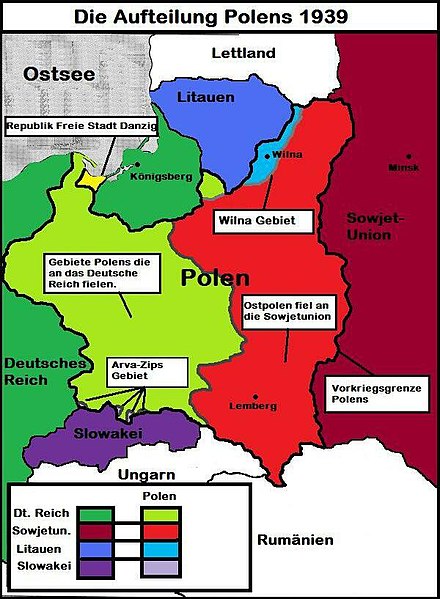
Deutsch: Die Teilung Polens 1939 Deutsch: The Partition of Poland 1939 |
| Date | |
| Source | Own work |
| Author | Mullerkingdom |
Licensing
[edit]
I, the copyright holder of this work, hereby publish it under the following license:
This file is licensed under the Creative Commons Attribution-Share Alike 3.0 Unported license.
- You are free:
- to share – to copy, distribute and transmit the work
- to remix – to adapt the work
- Under the following conditions:
- attribution – You must give appropriate credit, provide a link to the license, and indicate if changes were made. You may do so in any reasonable manner, but not in any way that suggests the licensor endorses you or your use.
- share alike – If you remix, transform, or build upon the material, you must distribute your contributions under the same or compatible license as the original.
| Annotations | This image is annotated: View the annotations at Commons |
File history
Click on a date/time to view the file as it appeared at that time.
| Date/Time | Thumbnail | Dimensions | User | Comment | |
|---|---|---|---|---|---|
| current | 14:53, 5 December 2022 | | 600 × 817 (83 KB) | Rémih (talk | contribs) | Cropped 8 % horizontally, 2 % vertically using CropTool with precise mode. Removed border. |
| 23:26, 31 January 2014 |  | 655 × 830 (92 KB) | Mullerkingdom (talk | contribs) | Suwalki area corrected | |
| 22:24, 31 January 2014 |  | 655 × 830 (95 KB) | Mullerkingdom (talk | contribs) | User created page with UploadWizard |
You cannot overwrite this file.
File usage on Commons
The following page uses this file:
File usage on other wikis
The following other wikis use this file:
- Usage on de.wikipedia.org
- Usage on en.wikipedia.org