File:Polartrails and foglake.jpg
![File:Polartrails and foglake.jpg](https://upload.wikimedia.org/wikipedia/commons/thumb/9/9d/Polartrails_and_foglake.jpg/800px-Polartrails_and_foglake.jpg?20150529210055)
Original file (1,080 × 721 pixels, file size: 531 KB, MIME type: image/jpeg)
Captions
Captions
Summary
[edit]DescriptionPolartrails and foglake.jpg |
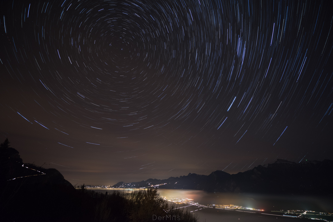
English: Polar trails over Lac Leman covered by fog. Composite 20-minute exposure from an altitude of 1000m in Valais, Switzerland. The fog covering the lake is slowly dissipating over the Rhone valley starting from the towns of Montreux and Villeneuve. The Dent de Jaman and the Rochers de Naye are visible in the middle of the picture. |
Date | |
Source | Own work |
Author | Dermits |
Camera location | 46° 19′ 12.62″ N, 6° 52′ 48.99″ E ![]() | View this and other nearby images on: OpenStreetMap | ![]() |
---|
Licensing
[edit]![w:en:Creative Commons](https://upload.wikimedia.org/wikipedia/commons/thumb/7/79/CC_some_rights_reserved.svg/90px-CC_some_rights_reserved.svg.png)
![attribution](https://upload.wikimedia.org/wikipedia/commons/thumb/1/11/Cc-by_new_white.svg/24px-Cc-by_new_white.svg.png)
![share alike](https://upload.wikimedia.org/wikipedia/commons/thumb/d/df/Cc-sa_white.svg/24px-Cc-sa_white.svg.png)
- You are free:
- to share – to copy, distribute and transmit the work
- to remix – to adapt the work
- Under the following conditions:
- attribution – You must give appropriate credit, provide a link to the license, and indicate if changes were made. You may do so in any reasonable manner, but not in any way that suggests the licensor endorses you or your use.
- share alike – If you remix, transform, or build upon the material, you must distribute your contributions under the same or compatible license as the original.
![]() |
This image was uploaded as part of Wiki Loves Earth 2015.
aragonés | العربية | asturianu | azərbaycanca | беларуская (тарашкевіца) | български | বাংলা | brezhoneg | català | čeština | Cymraeg | Deutsch | Ελληνικά | English | español | eesti | euskara | فارسی | français | galego | עברית | hrvatski | հայերեն | Bahasa Indonesia | italiano | 日本語 | ქართული | 한국어 | latviešu | македонски | മലയാളം | मराठी | Bahasa Melayu | norsk bokmål | नेपाली | Nederlands | norsk | polski | português | português do Brasil | русский | sicilianu | shqip | slovenščina | српски / srpski | svenska | ไทย | Türkçe | українська | اردو | 中文 | 中文(台灣) | +/− |
![]() |
File history
Click on a date/time to view the file as it appeared at that time.
Date/Time | Thumbnail | Dimensions | User | Comment | |
---|---|---|---|---|---|
current | 21:00, 29 May 2015 | ![]() | 1,080 × 721 (531 KB) | Dermits (talk | contribs) | User created page with UploadWizard |
You cannot overwrite this file.
File usage on Commons
There are no pages that use this file.
Metadata
This file contains additional information such as Exif metadata which may have been added by the digital camera, scanner, or software program used to create or digitize it. If the file has been modified from its original state, some details such as the timestamp may not fully reflect those of the original file. The timestamp is only as accurate as the clock in the camera, and it may be completely wrong.
Image title |
|
---|---|
Author | Der Mits |
Copyright holder |
|
User comments | Generate by Star Trails (Mac OS X) with 92 images |
Latitude | 46° 19′ 12.62″ N |
Longitude | 6° 52′ 48.99″ E |
Online copyright statement | www.dermits.com |
Short title |
|
Usage terms |
|
Horizontal resolution | 240 dpi |
Vertical resolution | 240 dpi |
Software used | Adobe Photoshop Lightroom 5.7.1 (Macintosh) |
File change date and time | 00:16, 24 February 2015 |
Exif version | 2.3 |
Date and time of digitizing | 15:38, 24 November 2014 |
GPS tag version | 0.0.2.2 |
Rating (out of 5) | 2 |
Date metadata was last modified | 01:16, 24 February 2015 |
Unique ID of original document | 9FFF55DF23AB6BDCC01E675AB225B0FD |
Copyright status | Copyrighted |
Keywords |
|
Contact information |
www.dermits.com
|
IIM version | 4 |
Structured data
Items portrayed in this file
depicts
some value
22 November 2014
46°19'12.618000001"N, 6°52'48.990000000"E
image/jpeg
- Files with coordinates missing SDC location of creation
- CC-BY-SA-3.0
- Self-published work
- Images from Wiki Loves Earth 2015
- Images from Wiki Loves Earth 2015 in Switzerland
- Images from Wiki Loves Earth missing SDC depicts
- Images from Wiki Loves Earth missing SDC location of creation
- Uploaded via Campaign:wle-ch