File:Polar Line in Salten and Ofoten map.svg
Jump to navigation
Jump to search

Size of this PNG preview of this SVG file: 583 × 600 pixels. Other resolutions: 233 × 240 pixels | 467 × 480 pixels | 747 × 768 pixels | 996 × 1,024 pixels | 1,991 × 2,048 pixels | 1,119 × 1,151 pixels.
Original file (SVG file, nominally 1,119 × 1,151 pixels, file size: 3.02 MB)
Captions
Captions
Add a one-line explanation of what this file represents
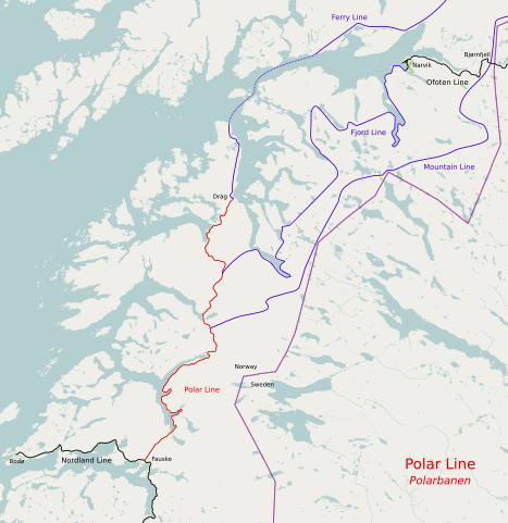
| Description | Map of the Polar Line in Salten and Ofoten, Norway. The red section between Fauske and Drag was under construction, but abandoned. The red lines show the three 1923 alternatives onwards to Narvik. |
| Date | |
| Source | Based on OpenStreetMap; additional work by myself |
| Author | OpenStreetMap and Arsenikk |
This file is licensed under the Creative Commons Attribution-Share Alike 2.0 Generic license.
- You are free:
- to share – to copy, distribute and transmit the work
- to remix – to adapt the work
- Under the following conditions:
- attribution – You must give appropriate credit, provide a link to the license, and indicate if changes were made. You may do so in any reasonable manner, but not in any way that suggests the licensor endorses you or your use.
- share alike – If you remix, transform, or build upon the material, you must distribute your contributions under the same or compatible license as the original.
File history
Click on a date/time to view the file as it appeared at that time.
| Date/Time | Thumbnail | Dimensions | User | Comment | |
|---|---|---|---|---|---|
| current | 18:31, 26 February 2012 | | 1,119 × 1,151 (3.02 MB) | Arsenikk (talk | contribs) | Attempt to remove black box and stray text |
| 18:27, 26 February 2012 |  | 1,119 × 1,151 (3.02 MB) | Arsenikk (talk | contribs) | {{Information |Description=Map of the Polar Line in Salten and Ofoten, Norway. The red section between Fauske and Drag was under construction, but abandoned. The red lines show the three 1923 alternatives onwards to Narvik. |Source=Based on OpenStreetM... |
You cannot overwrite this file.
File usage on Commons
There are no pages that use this file.
File usage on other wikis
The following other wikis use this file:
- Usage on da.wikipedia.org
- Usage on de.wikipedia.org
- Usage on en.wikipedia.org
- Usage on no.wikipedia.org