File:Poland, from Sławków to Dziłoszyce, photographed by the Corona 124 (KH-4A 1046-2) satellite (1968-03-25).png
Jump to navigation
Jump to search

Size of this preview: 800 × 327 pixels. Other resolutions: 320 × 131 pixels | 640 × 261 pixels | 1,024 × 418 pixels | 1,280 × 523 pixels | 2,560 × 1,045 pixels | 17,428 × 7,115 pixels.
Original file (17,428 × 7,115 pixels, file size: 58.11 MB, MIME type: image/png)
Captions
Captions
Add a one-line explanation of what this file represents
Summary
[edit]_satellite_(1968-03-25).png&action=edit§ion=1)
| Warning | The original file is very high-resolution. It might not load properly or could cause your browser to freeze when opened at full size. |
|---|
_satellite_(1968-03-25).png&flash=no)
| Description |
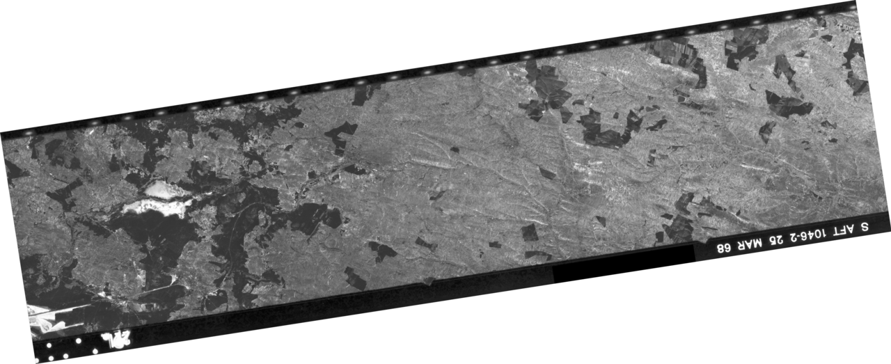
Polski: Obszar Polski, od Sławkowa do Działoszyc, sfotografowany 25 marca 1968 przez amerykańskiego satelitę wywiadowczego Corona 124 (KH-4A 1046-2). Zdjęcie stanowi część b klatki nr 34. Zdjęcie odbite lustrzanie w obu kierunkach i obrócone tak, aby odzwierciedlało rzeczywiste położenie sfotografowanych obiektów. Zdjęcie w połowie oryginalnej rozdzielczości. |
| Date | |
| Source | http://earthexplorer.usgs.gov/metadata/1051/DS1046-2168DA034/ |
| Author | CIA/NRO/USGS |
Licensing
[edit]_satellite_(1968-03-25).png&action=edit§ion=2)
| This work originally came from a National Reconnaissance Office (NRO) website or publication and has been specifically released into the public domain in the United States. Unless specifically released, NRO information should be assumed to be classified. The NRO seal is usage-restricted. See the site policy security notice and the site policy copyright notice for more information. Please note that if a copyright is indicated on a photo, graphic, or any other material, permission to copy these materials must be obtained from the original source.[1] |

|
| Annotations | This image is annotated: View the annotations at Commons |
_satellite_(1968-03-25).png)
File history
Click on a date/time to view the file as it appeared at that time.
| Date/Time | Thumbnail | Dimensions | User | Comment | |
|---|---|---|---|---|---|
| current | 07:45, 20 August 2014 | 17,428 × 7,115 (58.11 MB) | NH2501 (talk | contribs) | User created page with UploadWizard |
You cannot overwrite this file.
File usage on Commons
The following 2 pages use this file:
_satellite_(1968-03-25).png&oldid=797055113)