File:Planzeichnung-Olympisches-Dorf-(Berlin)-1936.svg
Jump to navigation
Jump to search

Size of this PNG preview of this SVG file: 800 × 566 pixels. Other resolutions: 320 × 226 pixels | 640 × 453 pixels | 1,024 × 724 pixels | 1,280 × 905 pixels | 2,560 × 1,810 pixels | 1,052 × 744 pixels.
Original file (SVG file, nominally 1,052 × 744 pixels, file size: 4.72 MB)
Captions
Captions
Add a one-line explanation of what this file represents
Summary
[edit]-1936.svg&action=edit§ion=1)
| Description |
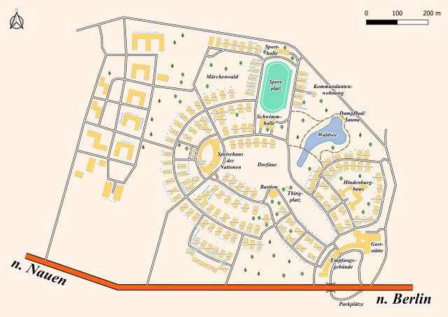
Deutsch: Karte des Olympischen Dorfs in Döberitz bei Berlin inklusive Namen der Häuser "Haus ..."(bei Unklarheit steht der Name nur in Klammern) und wichtiger Gebäude. Zudem ist die Belegung der Gebäude durch die teilnehmenden Nationen eingezeichnet.
Die Karten von damals sind ungenau und auch verfälscht. Mit Blick auf die nachfolgend geplante militärische Nutzung sind auch nicht alle Gebäude in den üblichen Werken verzeichnet gewesen (vor allem im Westteil der Anlage). Quellen:
- Dorf des Friedens, Hans Saalbach, Reclam Leipzig, 1936 |
| Date | |
| Source | Own work |
| Author | Florian Schäffer |
| Camera location | | View this and other nearby images on: OpenStreetMap |
|---|
-1936.svg¶ms=052.536534_N_0013.011460_E_globe:Earth_type:camera__&language=en)
Fehler und Hinweise bitte in der Diskussion vermerken
Licensing
[edit]-1936.svg&action=edit§ion=2)
I, the copyright holder of this work, hereby publish it under the following license:
This file is licensed under the Creative Commons Attribution-Share Alike 4.0 International license.
- You are free:
- to share – to copy, distribute and transmit the work
- to remix – to adapt the work
- Under the following conditions:
- attribution – You must give appropriate credit, provide a link to the license, and indicate if changes were made. You may do so in any reasonable manner, but not in any way that suggests the licensor endorses you or your use.
- share alike – If you remix, transform, or build upon the material, you must distribute your contributions under the same or compatible license as the original.
File history
Click on a date/time to view the file as it appeared at that time.
| Date/Time | Thumbnail | Dimensions | User | Comment | |
|---|---|---|---|---|---|
| current | 13:46, 27 April 2020 | | 1,052 × 744 (4.72 MB) | MAbW (talk | contribs) | Tunnel |
| 13:09, 27 April 2020 |  | 1,052 × 744 (4.71 MB) | MAbW (talk | contribs) | Uploaded own work with UploadWizard |
You cannot overwrite this file.
File usage on Commons
There are no pages that use this file.
File usage on other wikis
The following other wikis use this file:
- Usage on de.wikipedia.org
- Usage on fr.wikipedia.org
- Usage on pt.wikipedia.org
- Usage on sr.wikipedia.org
-1936.svg&oldid=503188807)