File:Plano del Puerto de la Guaira situado en la costa de Caracas en la latd. norte de 10 grads. y 37 minutos y en la longd. de 309 grados 47 minutos. LOC 90682976.jpg
Jump to navigation
Jump to search

Size of this preview: 800 × 570 pixels. Other resolutions: 320 × 228 pixels | 640 × 456 pixels | 1,024 × 730 pixels | 1,280 × 912 pixels | 2,560 × 1,825 pixels | 6,359 × 4,533 pixels.
Original file (6,359 × 4,533 pixels, file size: 2.99 MB, MIME type: image/jpeg)
Captions
Captions
Add a one-line explanation of what this file represents
Summary
[edit]| Description |
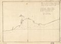
English: Shows coast of Venezuela in the region of La Guaira. Relief shown pictorially. Depths shown by soundings. Oriented with north to the bottom. Watermark: Van der Ley. Pen-and-ink. Mounted on cloth backing. LC Luso-Hispanic World, 1005 Available also through the Library of Congress Web site as a raster image. Indexed. Maggs number annotated in pencil in lower right margin: 128. Vault |
||
| Title | Plano del Puerto de la Guaira situado en la costa de Caracas en la latd. norte de 10 grads. y 37 minutos y en la longd. de 309 grados 47 minutos. | ||
| Shelf ID | G5284.L3A1 17-- .P5 | ||
| Date | |||
| Source | https://www.loc.gov/item/90682976/ | ||
| Author | Unknown author | ||
| Permission (Reusing this file) |
|
||
| Other versions |
|
||
| Location | La Guaira Region · Atlantic Coast. · Venezuela · Vargas · La Guaira Region (Distrito Federal) · Atlantic Coast · La Guaira Region (Distrito Federal) · Venezuela | ||
| Part of | American Memory · Catalog · Geography And Map Division · Cultural Landscapes | ||
| Subject | La Guaira Region (Vargas) · Coasts · Atlantic Coast (Venezuela) · Maps · Early Works To 1800 · Atlantic Coast · La Guaira Region (Distrito Federal) · La Guaira Region (Vargas, Venezuela) · Venezuela · Manuscript Maps |

Licensing
[edit]
|
This is a faithful photographic reproduction of a two-dimensional, public domain work of art. The work of art itself is in the public domain for the following reason:
The official position taken by the Wikimedia Foundation is that "faithful reproductions of two-dimensional public domain works of art are public domain".
This photographic reproduction is therefore also considered to be in the public domain in the United States. In other jurisdictions, re-use of this content may be restricted; see Reuse of PD-Art photographs for details. | ||||
File history
Click on a date/time to view the file as it appeared at that time.
| Date/Time | Thumbnail | Dimensions | User | Comment | |
|---|---|---|---|---|---|
| current | 23:01, 26 May 2018 | | 6,359 × 4,533 (2.99 MB) | Fæ (talk | contribs) | LOC Maps https://www.loc.gov/item/90682976/ #2195 |
You cannot overwrite this file.
File usage on Commons
The following page uses this file: