File:Plano de la Ría de San Yusti situado por obsevación (sic) la punta del N. del Castrón en la latitud N. de 43⁰18ʹ48ʺ LOC 91680959.jpg
Jump to navigation
Jump to search

Size of this preview: 751 × 600 pixels. Other resolutions: 301 × 240 pixels | 601 × 480 pixels | 962 × 768 pixels | 1,280 × 1,022 pixels | 2,560 × 2,044 pixels | 9,273 × 7,405 pixels.
Original file (9,273 × 7,405 pixels, file size: 7.24 MB, MIME type: image/jpeg)
Captions
Captions
Add a one-line explanation of what this file represents
Summary
[edit]| Description |
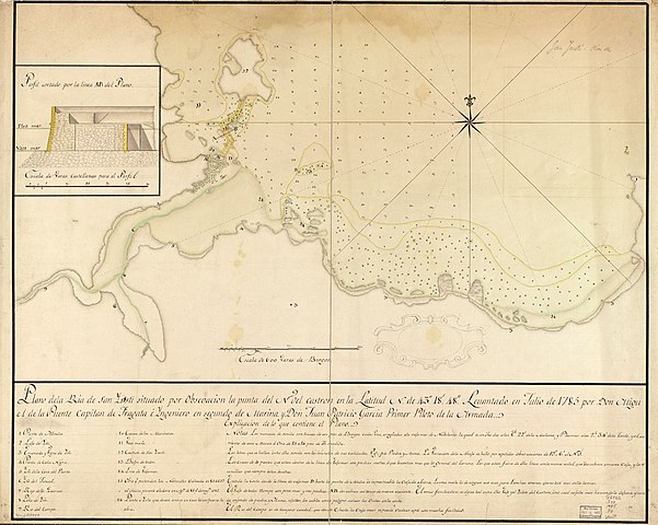
English: Also shows Ensenada de Mendía. Depths shown by soundings. Pen-and-ink and watercolors. Mounted on cloth backing. LC Luso-Hispanic World, 791 Available also through the Library of Congress Web site as a raster image. Includes cross section, index, and notes. Maggs number annotated in pencil in lower right margin: 92. Vault* |
||
| Title | Plano de la Ría de San Yusti situado por obsevación [sic] la punta del N. del Castrón en la latitud N. de 43⁰18ʹ48ʺ | ||
| Shelf ID | G6562.S38 1785 .P8 | ||
| Date | |||
| Source | https://www.loc.gov/item/91680959/ | ||
| Author | Puente, Miguel De La.; García, Juan Patricio | ||
| Permission (Reusing this file) |
|
||
| Other versions |
|
||
| Location | Atlantic Coast · Mendía Bay · Mendia Bay · Spain · Santiuste River | ||
| Part of | American Memory · Catalog · Geography And Map Division · Cultural Landscapes | ||
| Subject | Maps, Manuscript · Santiuste River (Spain) · Mendía Bay (Spain) · Atlantic Coast · Coasts · Santiuste River · Atlantic Coast (Spain) · Maps · Early Works To 1800 · Mendia Bay · Manuscript Maps · Mendía Bay · Spain |


_la_punta_del_N._del_Castr%C3%B3n_en_la_latitud_N._de_43%E2%81%B018%CA%B948%CA%BA_LOC_91680959.jpg&action=edit§ion=1)
Licensing
[edit]_la_punta_del_N._del_Castr%C3%B3n_en_la_latitud_N._de_43%E2%81%B018%CA%B948%CA%BA_LOC_91680959.jpg&action=edit§ion=2)
|
This is a faithful photographic reproduction of a two-dimensional, public domain work of art. The work of art itself is in the public domain for the following reason:
The official position taken by the Wikimedia Foundation is that "faithful reproductions of two-dimensional public domain works of art are public domain".
This photographic reproduction is therefore also considered to be in the public domain in the United States. In other jurisdictions, re-use of this content may be restricted; see Reuse of PD-Art photographs for details. | ||||
File history
Click on a date/time to view the file as it appeared at that time.
| Date/Time | Thumbnail | Dimensions | User | Comment | |
|---|---|---|---|---|---|
| current | 18:18, 7 June 2018 | | 9,273 × 7,405 (7.24 MB) | Fæ (talk | contribs) | LOC Maps https://www.loc.gov/item/91680959/ #7784 |
You cannot overwrite this file.
File usage on Commons
The following page uses this file:
_la_punta_del_N._del_Castrón_en_la_latitud_N._de_43⁰18ʹ48ʺ_LOC_91680959.jpg&oldid=424953212)