File:Plano Salinas San Pedro del Pinatar con leyenda.svg
Jump to navigation
Jump to search

Size of this PNG preview of this SVG file: 382 × 599 pixels. Other resolutions: 153 × 240 pixels | 306 × 480 pixels | 490 × 768 pixels | 653 × 1,024 pixels | 1,307 × 2,048 pixels | 388 × 608 pixels.
Original file (SVG file, nominally 388 × 608 pixels, file size: 27 KB)
Captions
Captions
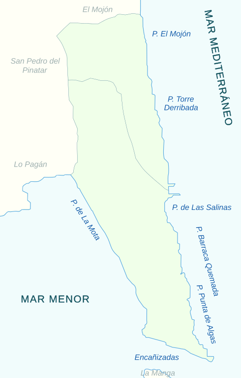
Map of Salinas San Pedro del Pinatar with legend
Summary
[edit]
| Description |
Español: Plano Salinas San Pedro del Pinatar (Región de Murcia, España), con leyenda. Es un Espacio Natural Protegido de la comunidad autónoma, flanqueado por el Mar Menor y el Mar Mediterráneo. Es una versión SVG del siguiente archivo: https://commons.wikimedia.org/wiki/File:Planosalinas.jpg, Nioger, CC BY-SA 3.0 <http://creativecommons.org/licenses/by-sa/3.0/>, via Wikimedia Commons |
| Date | |
| Source |
 |
| Author | Nioger |
Licensing
[edit]
I, the copyright holder of this work, hereby publish it under the following license:
This file is licensed under the Creative Commons Attribution-Share Alike 4.0 International license.
- You are free:
- to share – to copy, distribute and transmit the work
- to remix – to adapt the work
- Under the following conditions:
- attribution – You must give appropriate credit, provide a link to the license, and indicate if changes were made. You may do so in any reasonable manner, but not in any way that suggests the licensor endorses you or your use.
- share alike – If you remix, transform, or build upon the material, you must distribute your contributions under the same or compatible license as the original.
File history
Click on a date/time to view the file as it appeared at that time.
| Date/Time | Thumbnail | Dimensions | User | Comment | |
|---|---|---|---|---|---|
| current | 18:12, 20 April 2024 | | 388 × 608 (27 KB) | Anidae (talk | contribs) | Uploaded own work with UploadWizard |
You cannot overwrite this file.
File usage on Commons
The following 3 pages use this file:
File usage on other wikis
The following other wikis use this file:
- Usage on ca.wikipedia.org
- Usage on es.wikipedia.org
- Usage on nl.wikipedia.org
- Usage on www.wikidata.org