File:Plan tramway reims.png
Jump to navigation
Jump to search
Size of this preview: 271 × 600 pixels. Other resolutions: 108 × 240 pixels | 217 × 480 pixels | 1,000 × 2,213 pixels.
Original file (1,000 × 2,213 pixels, file size: 2.33 MB, MIME type: image/png)
Captions
Captions
Add a one-line explanation of what this file represents
Summary
[edit]
| Description |
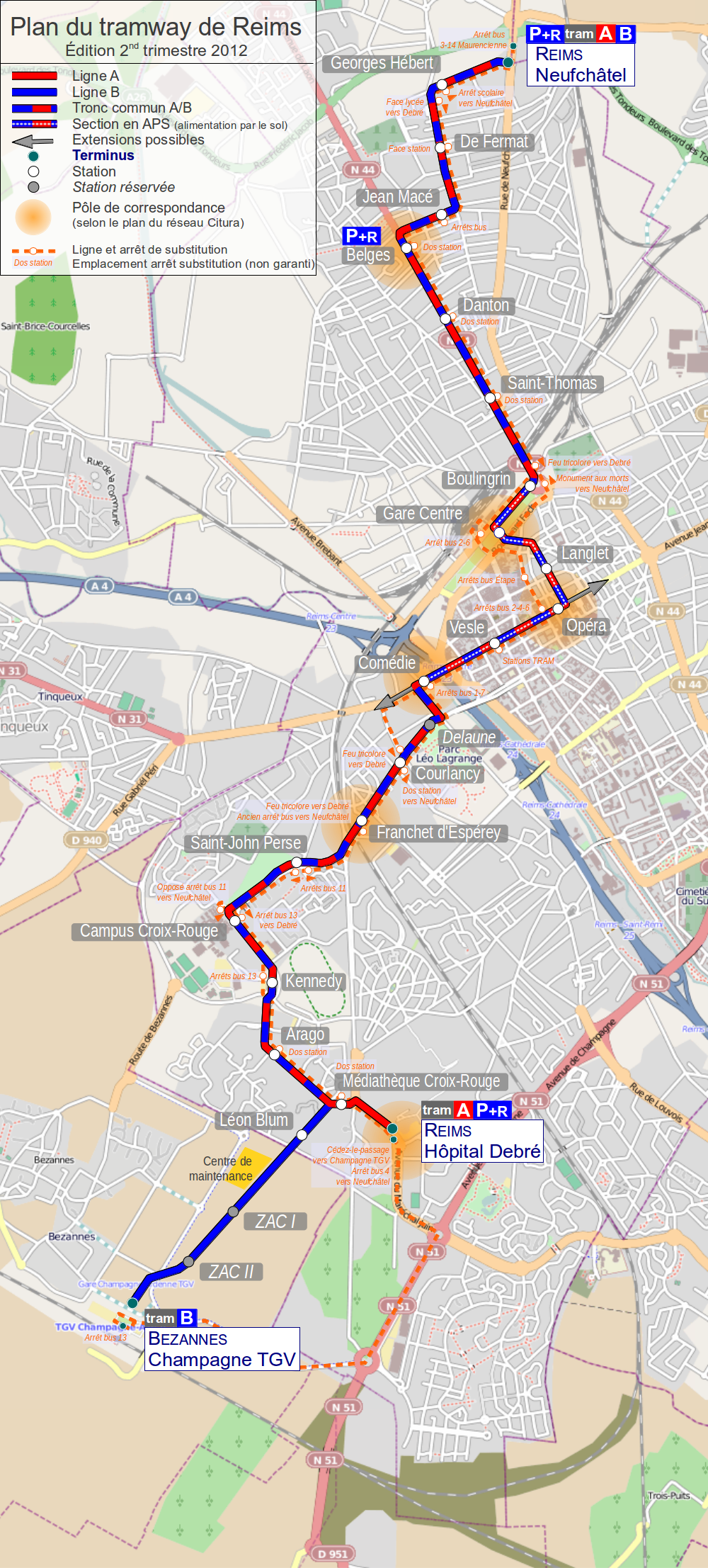
English: Map of tramway in Rheims France
Français : Plan du tramway de Reims, France |
| Date | |
| Source | Own work. Background map: © OpenStreetMap and contributors, CC BY-SA. |
| Author | Daiima |
Licensing
[edit]
This file is licensed under the Creative Commons Attribution-Share Alike 2.0 Generic license.
- You are free:
- to share – to copy, distribute and transmit the work
- to remix – to adapt the work
- Under the following conditions:
- attribution – You must give appropriate credit, provide a link to the license, and indicate if changes were made. You may do so in any reasonable manner, but not in any way that suggests the licensor endorses you or your use.
- share alike – If you remix, transform, or build upon the material, you must distribute your contributions under the same or compatible license as the original.
File history
Click on a date/time to view the file as it appeared at that time.
| Date/Time | Thumbnail | Dimensions | User | Comment | |
|---|---|---|---|---|---|
| current | 20:43, 2 April 2012 | | 1,000 × 2,213 (2.33 MB) | Daiima (talk | contribs) | Visiblement l'upload s'est mal déroulé, nouvelle tentative |
| 20:39, 2 April 2012 |  | 1,000 × 2,213 (2.33 MB) | Daiima (talk | contribs) | Ajout ligne substitution | |
| 13:50, 29 August 2011 |  | 695 × 1,538 (1.31 MB) | Daiima (talk | contribs) | Mise à jour rentrée 2011 ligne B jusqu'à Neufchâtel | |
| 18:16, 7 February 2011 |  | 695 × 1,538 (3.06 MB) | Daiima (talk | contribs) | stations projetées sur bezannes | |
| 22:12, 28 December 2010 |  | 695 × 1,538 (3.06 MB) | Daiima (talk | contribs) | updates | |
| 15:36, 12 October 2010 |  | 695 × 1,538 (3.06 MB) | Daiima (talk | contribs) | + Centre de Maintenance | |
| 12:15, 12 October 2010 |  | 695 × 1,538 (3.06 MB) | Daiima (talk | contribs) | + Park-and-Ride | |
| 12:08, 12 October 2010 |  | 695 × 1,538 (3.06 MB) | Daiima (talk | contribs) | {{Information |Description={{en|1=Map of tramway in Rheims France}} {{fr|1=Plan du tramway de Reims, France}} |Source={{own}} |Author=Daiima |Date=2010/10/12 |Permission= |other_versions= }} Category:Public transport maps of Reims |
You cannot overwrite this file.
File usage on Commons
The following page uses this file:
File usage on other wikis
The following other wikis use this file:
- Usage on als.wikipedia.org
- Usage on de.wikipedia.org
- Usage on eo.wikipedia.org
- Usage on fr.wikipedia.org
- Usage on hu.wikipedia.org
- Usage on it.wikipedia.org
- Usage on ja.wikipedia.org
- Usage on nl.wikipedia.org
- Usage on pl.wikipedia.org
- Usage on ru.wikipedia.org
- Usage on uk.wikipedia.org
- Usage on www.wikidata.org