File:Plan showing the boundaries of the great conflagration of New Orleans on the 21st of March 1788. LOC 2001620435.jpg
Jump to navigation
Jump to search

Size of this preview: 769 × 600 pixels. Other resolutions: 308 × 240 pixels | 616 × 480 pixels | 985 × 768 pixels | 1,280 × 998 pixels | 2,560 × 1,997 pixels | 3,580 × 2,792 pixels.
Original file (3,580 × 2,792 pixels, file size: 1.55 MB, MIME type: image/jpeg)
Captions
Captions
Add a one-line explanation of what this file represents
Summary
[edit]| Description |
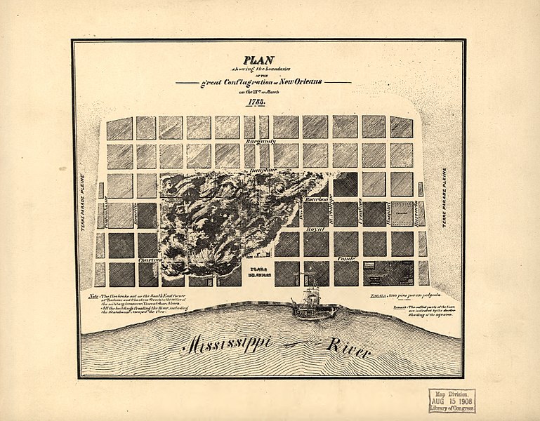
English: Shows settled parts of the town with the darker shading of the squares. Also indicates where fire started and which buildings escaped the fire. Facsimile. Available also through the Library of Congress web site as a raster image. |
||
| Title | Plan showing the boundaries of the great conflagration of New Orleans on the 21st of March 1788. | ||
| Shelf ID | G4014.N5 1788 .P5 190- TIL | ||
| Date | 1900s | ||
| Source | https://www.loc.gov/item/2001620435/ | ||
| Author | Unknown author | ||
| Permission (Reusing this file) |
|
||
| Other versions |
|
||
| Location | United States · Lousiana · New Orleans · Louisiana | ||
| Part of | American Memory · Cities And Towns · Catalog · Geography And Map Division | ||
| Subject | New Orleans (La.) · United States · Maps · Early Works To 1800 · New Orleans · Louisiana |


Licensing
[edit]
|
This is a faithful photographic reproduction of a two-dimensional, public domain work of art. The work of art itself is in the public domain for the following reason:
The official position taken by the Wikimedia Foundation is that "faithful reproductions of two-dimensional public domain works of art are public domain".
This photographic reproduction is therefore also considered to be in the public domain in the United States. In other jurisdictions, re-use of this content may be restricted; see Reuse of PD-Art photographs for details. | ||||
File history
Click on a date/time to view the file as it appeared at that time.
| Date/Time | Thumbnail | Dimensions | User | Comment | |
|---|---|---|---|---|---|
| current | 09:22, 10 May 2018 | | 3,580 × 2,792 (1.55 MB) | Fæ (talk | contribs) | LOC Maps https://www.loc.gov/item/2001620435/ #8007 |
You cannot overwrite this file.
File usage on Commons
The following page uses this file: