File:Plan of the Battle of Brandywine.jpg
Jump to navigation
Jump to search
Size of this preview: 452 × 599 pixels. Other resolutions: 181 × 240 pixels | 362 × 480 pixels | 580 × 768 pixels | 773 × 1,024 pixels | 1,471 × 1,949 pixels.
Original file (1,471 × 1,949 pixels, file size: 672 KB, MIME type: image/jpeg)
Captions
Captions
Add a one-line explanation of what this file represents
| Description |
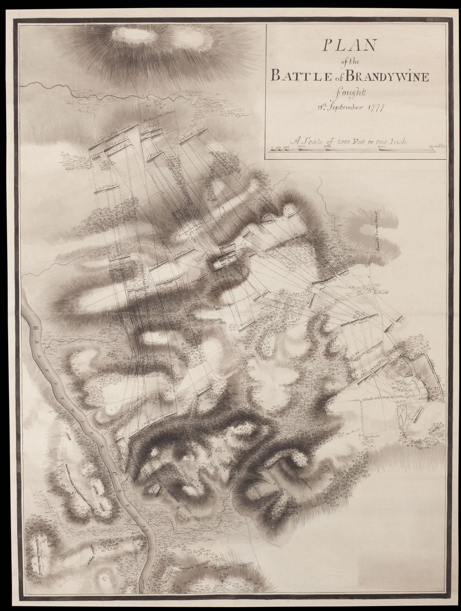
English: This detailed plan shows British, Hessian, and American troop positions and movements during the Battle of Brandywine, September 11, 1777. This hard-fought action ended with Washington’s army withdrawing east towards Chester, Pennsylvania. The exhausted Crown forces encamped at Dilworth (visible at the right-center of this plan) and neighboring areas until September 15, when they resumed pursuit of Washington’s forces before capturing Philadelphia on September 26, 1777. During the four-day encampment on the battlefield, British engineers surveyed the area and recorded details of the engagement in a series of plans, including this example. |
| Date | |
| Source |
Original publication: 1777 in or around Chester County, Pennsylvania by the British Army |
| Author |
British Army |
This work is in the public domain in the United States because it was published (or registered with the U.S. Copyright Office) before January 1, 1929.
Public domain works must be out of copyright in both the United States and in the source country of the work in order to be hosted on the Commons. If the work is not a U.S. work, the file must have an additional copyright tag indicating the copyright status in the source country.
Note: This tag should not be used for sound recordings. |
File history
Click on a date/time to view the file as it appeared at that time.
| Date/Time | Thumbnail | Dimensions | User | Comment | |
|---|---|---|---|---|---|
| current | 19:53, 30 March 2013 | | 1,471 × 1,949 (672 KB) | JC1008 (talk | contribs) | {{subst:Upload marker added by en.wp UW}} {{Information |Description = {{en|This detailed plan shows British, Hessian, and American troop positions and movements during the Battle of Brandywine, September 11, 1777. This hard-fought action ended with Wa... |
You cannot overwrite this file.
File usage on Commons
There are no pages that use this file.
File usage on other wikis
The following other wikis use this file:
- Usage on bn.wikipedia.org
- Usage on en.wikipedia.org