File:Plan of part of the Province of Lower Canada, 1795.jpg
Jump to navigation
Jump to search
Size of this preview: 800 × 295 pixels. Other resolutions: 320 × 118 pixels | 1,024 × 378 pixels.
Original file (1,024 × 378 pixels, file size: 81 KB, MIME type: image/jpeg)
Captions
Captions
Add a one-line explanation of what this file represents
Summary
[edit]
| Description |
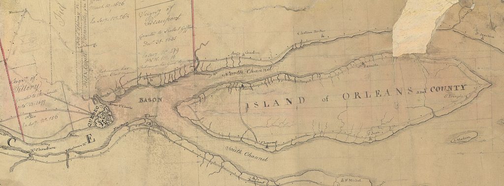
English: Plan of part of the Province of Lower Canada
Français : Compilation d'une partie de la province du Bas-Canada, rive nord du fleuve St-Laurent, de la Côte-de-Beaupré au Lac St-Pierre; Couvrant les comtés de Québec, Hampshire, St-Maurice et Warwick . |
| Date | |
| Source | blogues.banq.qc.ca - pistard.banq.qc.ca |
| Author | Jean-Baptiste Duberger |
Licensing
[edit]
|
This work is in the public domain in its country of origin and other countries and areas where the copyright term is the author's life plus 100 years or fewer. | |
| This file has been identified as being free of known restrictions under copyright law, including all related and neighboring rights. | |
File history
Click on a date/time to view the file as it appeared at that time.
| Date/Time | Thumbnail | Dimensions | User | Comment | |
|---|---|---|---|---|---|
| current | 09:12, 22 September 2017 | 1,024 × 378 (81 KB) | Jeangagnon (talk | contribs) | {{Information |Description ={{en|1=Plan of part of the Province of Lower Canada }} {{fr|1=Compilation d'une partie de la province du Bas-Canada, rive nord du fleuve St-Laurent, de la Côte-de-Beaupré au Lac St-Pierre; Couvrant les comtés de Québe... |
You cannot overwrite this file.
File usage on Commons
There are no pages that use this file.
File usage on other wikis
The following other wikis use this file:
- Usage on fr.wikipedia.org