File:Plan of Ternate - (Dutch East Indies). LOC 2010588436.jpg
Jump to navigation
Jump to search

Size of this preview: 800 × 286 pixels. Other resolutions: 320 × 114 pixels | 640 × 229 pixels | 1,024 × 366 pixels | 1,280 × 458 pixels | 2,560 × 916 pixels | 17,704 × 6,333 pixels.
Original file (17,704 × 6,333 pixels, file size: 10.86 MB, MIME type: image/jpeg)
Captions
Captions
Add a one-line explanation of what this file represents
Summary
[edit]| Warning | The original file is very high-resolution. It might not load properly or could cause your browser to freeze when opened at full size. |
|---|
| Description |
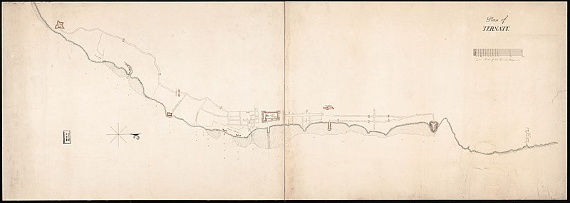
English: Ms. topographic map of the town of Ternate (on Ternate Island, Dutch East Indies) showing streets, roads, fortifications, beaches, and gates across roads. Does not cover entire Ternate Island. Shows British flag in "Fort Orange". Depths shown by soundings. Watermark: Crown over unidentified escutcheon dated [1807?-date unclear, accompanying wording unclear]. One of the ms. maps of the Indonesian archipelago formerly in the possession of Gilbert Elliot, 1st Earl of Minto, and Governor General of India, 1807-1814. Oriented with north to the right. Manuscript: Pen-and-ink and watercolors (gray, light blue, and red outlines of fortifications). Sheet halved and mounted on cloth backing. Includes bar "Scale of 200 Dutch roods". Available also through the Library of Congress Web site as a raster image. Filed in the Minto Collection drawer--G8090 area of vault maps. |
||
| Title | Plan of Ternate : [Dutch East Indies]. | ||
| Shelf ID | G8074.T45 1807 .P5 | ||
| Date | |||
| Source | https://www.loc.gov/item/2010588436/ | ||
| Author | Minto, Gilbert Elliot | ||
| Permission (Reusing this file) |
|
||
| Other versions |
|
||
| Location | Ternate · Indonesia | ||
| Part of | Military Battles And Campaigns · Cities And Towns · Catalog · American Memory · Geography And Map Division | ||
| Subject | Maps, Manuscript · Maps, Topographic · Fortification · Indonesia · Maps · Ternate · Ternate (Indonesia) |

._LOC_2010588436.jpg&action=edit§ion=1)
._LOC_2010588436.jpg&flash=no)
Licensing
[edit]._LOC_2010588436.jpg&action=edit§ion=2)
|
This is a faithful photographic reproduction of a two-dimensional, public domain work of art. The work of art itself is in the public domain for the following reason:
The official position taken by the Wikimedia Foundation is that "faithful reproductions of two-dimensional public domain works of art are public domain".
This photographic reproduction is therefore also considered to be in the public domain in the United States. In other jurisdictions, re-use of this content may be restricted; see Reuse of PD-Art photographs for details. | ||||
File history
Click on a date/time to view the file as it appeared at that time.
| Date/Time | Thumbnail | Dimensions | User | Comment | |
|---|---|---|---|---|---|
| current | 20:25, 11 August 2018 | 17,704 × 6,333 (10.86 MB) | Fæ (talk | contribs) | LOC Maps https://www.loc.gov/item/2010588436/ #32361 |
You cannot overwrite this file.
File usage on Commons
The following page uses this file:
._LOC_2010588436.jpg&oldid=859179491)