File:Plan of Jerusalem 01 (FL155882602 3910925).jpg
Jump to navigation
Jump to search

Size of this preview: 799 × 600 pixels. Other resolutions: 320 × 240 pixels | 640 × 480 pixels | 1,023 × 768 pixels | 1,280 × 961 pixels | 2,560 × 1,921 pixels | 4,703 × 3,530 pixels.
Original file (4,703 × 3,530 pixels, file size: 22.38 MB, MIME type: image/jpeg)
Captions
Captions
Add a one-line explanation of what this file represents
Summary
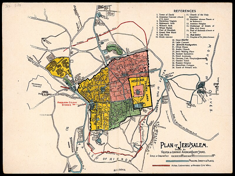
[edit]| Plan of Jerusalem
( |
||||||||||||||||||||||||
|---|---|---|---|---|---|---|---|---|---|---|---|---|---|---|---|---|---|---|---|---|---|---|---|---|
| Title |
Plan of Jerusalem |
|||||||||||||||||||||||
| Publisher |
Vester & Companythe American Colony Stores |
|||||||||||||||||||||||
| Description |
Plan of Jerusalem. Issued by Vester & Company American Colony Stores. |
|||||||||||||||||||||||
| Language | English | |||||||||||||||||||||||
| Publication date | 1925 possibly | |||||||||||||||||||||||
| Medium | 1 sheet : color ; | |||||||||||||||||||||||
| Dimensions | height: 14 cm (5.5 in); width: 20 cm (7.8 in) | |||||||||||||||||||||||
| Collection |
|
|||||||||||||||||||||||
| Current location |
|
|||||||||||||||||||||||
| Place of publication | Jerusalem | |||||||||||||||||||||||
| search Merhav catalog | Jerusalem | |||||||||||||||||||||||
| Notes | Issued by Vester & Company American Colony Stores.; Includes index.; On cover: Compliments of Vester & Company The American Colony Stores, oriental articles of every description. Jaffa Gate, Jerusalem, Palestine. | |||||||||||||||||||||||
| IE PID | IE155882599 | |||||||||||||||||||||||
| Rosetta filename | FL155882602 | |||||||||||||||||||||||
| NNL item ID (P3959) | 990039109250205171 | |||||||||||||||||||||||
| search Merhav catalog | English | |||||||||||||||||||||||
| search Merhav catalog | Vester & Companythe American Colony Stores | |||||||||||||||||||||||
| Source/Photographer |
|
|||||||||||||||||||||||
| Other versions | ||||||||||||||||||||||||
| Jpg / Tif version |
|
|||||||||||||||||||||||

.jpg)

.jpg&action=edit§ion=1)
Licensing
[edit].jpg&action=edit§ion=2)
This work is in the public domain because it was published in the United States between 1929 and 1963, and although there may or may not have been a copyright notice, the copyright was not renewed. For further explanation, see Commons:Hirtle chart and the copyright renewal logs.
|
 |
File history
Click on a date/time to view the file as it appeared at that time.
| Date/Time | Thumbnail | Dimensions | User | Comment | |
|---|---|---|---|---|---|
| current | 21:33, 3 September 2023 | | 4,703 × 3,530 (22.38 MB) | Geagea (talk | contribs) | pattypan 22.03 |
You cannot overwrite this file.
File usage on Commons
The following page uses this file:
.jpg&oldid=798244159)